Difference between revisions of "2013-07-16 54 -1"
From Geohashing
imported>JMuonio |
imported>JMuonio |
||
| Line 44: | Line 44: | ||
Image:2013-07-16_54_-1_JJCircus.JPG| Jess attempting to do the acrobatic thing. | Image:2013-07-16_54_-1_JJCircus.JPG| Jess attempting to do the acrobatic thing. | ||
Image:2013-07-16_54_-1_JJCircus2.JPG| Jake and Jess make excellent clowns. | Image:2013-07-16_54_-1_JJCircus2.JPG| Jake and Jess make excellent clowns. | ||
| + | Image:2013-07-16_54_-1_JJGKcoordinates.JPG| We made it! When checking the GPS feature on getting out of the car, we were 773 feet but made it to 0.03 yards of the point. | ||
</gallery> | </gallery> | ||
Revision as of 20:06, 17 July 2013

| Tue 16 Jul 2013 in 54,-1: 54.6722626, -1.6238778 geohashing.info google osm bing/os kml crox |
Location
Wheat Field to the northeast of Bishop Auckland, County Durham, UK
Participants
Expedition
While playing Citadels, Jessica was excited because the hashpoint was not far from our home so we decided to take advantage of the beautiful day and head out.
Photos
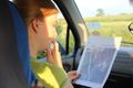
Katja trying to find the trees to match her map.
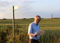
George found a tractor path to get us into the field to the hashpoint.

George happened to have bowling pins available to juggle with.

Katja shows off her circus talent with two foam bowling balls.
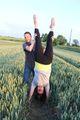
Jess attempting to do the acrobatic thing.

Jake and Jess make excellent clowns.
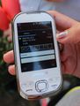
We made it! When checking the GPS feature on getting out of the car, we were 773 feet but made it to 0.03 yards of the point.


Achievements
George, Katja, Jake, and Jessica earned the Land geohash achievement
|
George, Katja, Jake, and Jessica earned the Circus Geohash Achievement
|