Difference between revisions of "2013-08-07 32 -117"
From Geohashing
imported>LucasBrown |
imported>LucasBrown ((LucasBrown) Geohash Droid details page at hashpoint) |
||
| Line 50: | Line 50: | ||
--> | --> | ||
<gallery perrow="5"> | <gallery perrow="5"> | ||
| + | |||
| + | Image:2013-08-07_32_-117_16-48-54-661.jpg | ([[User:LucasBrown|LucasBrown]]) Geohash Droid details page at hashpoint | ||
</gallery> | </gallery> | ||
Revision as of 23:49, 7 August 2013
| Wed 7 Aug 2013 in 32,-117: 32.9344231, -117.0076424 geohashing.info google osm bing/os kml crox |
Location
Atop a ridge off the end of Santa Era in Rancho Encantada, an under-development road and residential zone on the south side of Beeler Canyon in San Diego, CA just south of the border with Poway
Participants
- LucasBrown (independent expedition)
Plans
- Going to a doctor's appointment now and will hit the hashpoint on the way back. Should get to the closest vehicular approach or the end of Stonebridge Parkway (depending on whether I feel like climbing up and down two 200' steepish hills) at 15:10 or so and will walk to the hashpoint from there. -- LucasBrown
Expedition
LucasBrown: I went to the closest vehicular approach—a spot along Via Santa Pradera—at about 15:30 and took my time hiking a few hundred meters across a small valley to reach the hashpoint (reaching it at 15:52) before to the car by walking along the ridgelines under the gentle cooling of a light breeze. I crossed paths with another hiker wearing a dark blue T-shirt and jeans shorts but didn't stop to say hi or anything because speech issues.
Tracklog
Photos
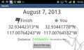
(LucasBrown) Geohash Droid details page at hashpoint

Achievements