Difference between revisions of "2013-08-11 53 -2"
From Geohashing
imported>Angel ([live picture] A screenshot at the point; unfortunately the satellite image went black on me, but you can see my location and the flag [http://www.openstreetmap.org/?lat=53.62040701&lon=-2.53788267&zoom=16&layers=B000FTF @53.6204,-2.5379]) |
imported>Angel (→Achievements) |
||
| Line 53: | Line 53: | ||
{{#vardefine:ribbonwidth|800px}} | {{#vardefine:ribbonwidth|800px}} | ||
<!-- Add any achievement ribbons you earned below, or remove this section --> | <!-- Add any achievement ribbons you earned below, or remove this section --> | ||
| − | + | {{drag-along | latitude = 53 | longitude = -2 | date = 2013-08-11 | partner = Mum & Dennis | name = Angel }} | |
<!-- =============== USEFUL CATEGORIES FOLLOW ================ | <!-- =============== USEFUL CATEGORIES FOLLOW ================ | ||
Delete the next line ONLY if you have chosen the appropriate categories below. If you are unsure, don't worry. People will read your report and help you with the classification. --> | Delete the next line ONLY if you have chosen the appropriate categories below. If you are unsure, don't worry. People will read your report and help you with the classification. --> | ||
| − | |||
| − | + | [[Category:Expeditions]] | |
| − | |||
| − | [[Category: | ||
| − | |||
| − | |||
| − | |||
| − | |||
[[Category:Expeditions with photos]] | [[Category:Expeditions with photos]] | ||
| − | |||
[[Category:Expedition without GPS]] | [[Category:Expedition without GPS]] | ||
| − | |||
| − | |||
[[Category:Coordinates reached]] | [[Category:Coordinates reached]] | ||
| − | |||
| − | |||
| − | |||
| − | |||
| − | |||
| − | |||
| − | |||
| − | |||
| − | |||
| − | |||
| − | |||
| − | |||
| − | |||
| − | |||
| − | |||
| − | |||
| − | |||
| − | |||
Revision as of 17:16, 11 August 2013
| Sun 11 Aug 2013 in 53,-2: 53.6201854, -2.5367449 geohashing.info google osm bing/os kml crox |
Location
Participants
Plans
Expedition
- On my way now; looks just below Rivington Pike. But my phone's browser is being odd with the wiki, so I'm posting from the Geohash Droid app again (hence lack of formatting) -- Angel (talk) @53.5616,-2.6983 09:37, 11 August 2013 (EDT)
- Rivington car park, and the distance is flickering between 5xxx feet and 1.05 miles; so not too far to walk -- Angel (talk) @53.6224,-2.5600 10:04, 11 August 2013 (EDT)
Tracklog
Photos
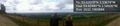
Half way there :) @53.6248,-2.5461
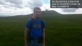
Made it :) With my mum and her bf, which I think earns me a new achievement. @53.6202,-2.5368
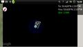
A screenshot at the point; unfortunately the satellite image went black on me, but you can see my location and the flag @53.6204,-2.5379


Achievements
Angel earned the Drag-along achievement
|