Difference between revisions of "2013-09-18 -34 142"
From Geohashing
imported>Felix Dance (More on expedition) |
imported>Felix Dance m |
||
| Line 28: | Line 28: | ||
{{Land geohash | {{Land geohash | ||
| − | | latitude = - | + | | latitude = -35 |
| − | | longitude = | + | | longitude = 142 |
| − | | date = 2013- | + | | date = 2013-09-18 |
| − | | name = [[User:Felix Dance|Felix Dance]] | + | | name = [[User:Felix Dance|Felix Dance]] and Tom |
| − | | image = Geohash 2013 | + | | image = Geohash -35 142 2013-09-18 Felix Tom.JPG|Felix and Tom at the hash |
}} | }} | ||
Revision as of 00:17, 21 September 2013
| Wed 18 Sep 2013 in -34,142: -34.3777205, 142.1016529 geohashing.info google osm bing/os kml crox |
Contents
[hide]Location
On a dirt road near Red Cliffs.
Who went
- Felix Dance
- Tom
Expedition
Our route for the whole tour is here
Photos
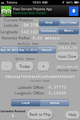
Phone GPS Proof
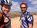
Felix and Tom at the hash
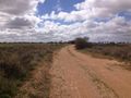
The dirt hashroad


Achievement
Felix Dance and Tom earned the Land geohash achievement
|