Difference between revisions of "St. John's, Newfoundland and Labrador"
imported>Thomcat m |
imported>Moose Hole m (Updated neighbors) |
||
| Line 1: | Line 1: | ||
| + | {{graticule | ||
| + | |map = <map lat="47" lon="-52" /> | ||
| + | |w = [[Bay Roberts, Newfoundland and Labrador]] | ||
| + | |e = [[Atlantic Ocean]] | ||
| + | }} | ||
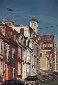
[[Image:St_Johns-DT.jpg|thumb|222px|Some houses in the downtown area of St. John's]] | [[Image:St_Johns-DT.jpg|thumb|222px|Some houses in the downtown area of St. John's]] | ||
Revision as of 18:33, 11 July 2008
| – | – | – |
| Bay Roberts, Newfoundland and Labrador | St. John's, Newfoundland and Labrador | Atlantic Ocean |
| – | – | – |
[[Category:Meetup in {{{lat}}} {{{lon}}}| ]]
Today's Location: [St. John's]
The St. John's Graticule is located at (47, longitude -52). Being the capital of Newfoundland and Labrador it is the center of good times and great people. It has the street with the most bars per unit length probably in North America, George Street. Also home to Memorial University of Newfoundland, we should see a good turn out of XKCD fans when the school year is in. That is at least when our Saturday meeting is not water logged as about 80% of our Graticule is the Atlantic ocean. If this is the case we shall meet up at The Duke of Duckworth in downtown St. John's!
Activities
Once again our meetup point is many miles into ocean territory. Instead of the duke this week I suggest meeting up with my little group for a bonfire on topsail beach at 9pm, comestibles and combustibles welcome. ~StephenC
Geohashing
Link to the Graticule on the coordinate calculator
Please post your pictures and locations of whatever dry land (or wet ocean) you get to see.
Local Geohashers
Stephen C came for his masters work, and fell in love with St. John's.
