Difference between revisions of "2013-09-27 42 -88"
imported>Mystrsyko m |
imported>Mystrsyko |
||
| Line 1: | Line 1: | ||
| − | |||
| − | |||
| − | |||
| − | |||
| − | |||
| − | |||
| − | |||
| − | |||
| − | |||
| − | |||
{{meetup graticule | {{meetup graticule | ||
| lat=42 | | lat=42 | ||
| Line 15: | Line 5: | ||
}} | }} | ||
| − | |||
__NOTOC__ | __NOTOC__ | ||
== Location == | == Location == | ||
| − | Alongside the Fox River in Carpentersville, IL | + | Alongside the Fox River in Carpentersville, IL |
== Participants == | == Participants == | ||
| − | [[User:Mystrsyko|Mystrsyko]] ([[User talk:Mystrsyko|talk]]) | + | [[User:Mystrsyko|Mystrsyko]] ([[User talk:Mystrsyko|talk]]) |
| − | + | ||
| + | == Expedition == | ||
| + | When I checked the area hash points in the morning, I was quite surprised to see that this one was 1: not in Wisconsin, and 2: in a forest preserve, meaning public lands. I debated whether or not to go when I noticed that it was about a mile from Raceway Woods, a forest preserve in Carpentersville that contains the abandoned Meadowdale Raceway. I've been wanting to go there for a few years, but could never justify the trip up from Bolingbrook. I then checked the weather and saw 78° and sunny in the forecast. That settled it, I had to go! | ||
| + | |||
| + | From the aerial photos it looked like the point was in a flood plain, so I packed an extra set of clothes, my camera gear, and my bike into my sister's van and headed out. The drive was uneventful and I arrived at the Raceway Woods parking lot off Route 31 shortly after 13:30. With so much daylight left, I decided that the hash point could wait, and headed to the front straight of the old track on my bike to do a lap. I was completely unprepared for the elevation changes. Down the front stretch I easily coasted to 40mph, navigated the downhill first turn at 35mph, which was terrifying, and couldn't pedal my way up the hill after the "esses". I couldn't ride up the hill onto the back stretch either, so I stopped to rest and take photos on the old racing surface. After a few minutes, I completed my lap (3.2 miles in 20.5 minutes!) and headed back to the van, where I guzzled the remainder of my water and considered taking a short nap before heading for the hash. | ||
| − | + | After resting up for a bit, I decided that naps were for babies and headed out on foot around 14:45. The plan was to walk down Commerce Parkway, which led into an industrial park, and off the end into the woods. That plan was shot down by a prominent "No Trespassing" sign at the end of the road. I back tracked to Route 31 and walked over to the corn field adjacent to the industrial park. The thinking was that if I walked through the brush along the border of the crops, I wouldn't technically be on industrial property, and wouldn't technically be in the field either. Before I got more than halfway down the length of the field, however, I encountered many thorns and burrs, and with my athletic shorts covered in them, decided that walking the additional mile to the hash was not a good idea. I retreated back to the van to change into the heavy jeans I had brought with. | |
| − | |||
| − | + | Now making my third attempt to reach the hash, I had no problem fighting through the brush and thorns to the rear of the field where I encountered shoulder high prairie grasses. I stopped in a small clearing for a photo, then proceeded into the trees. The vegetation changed almost too quickly to photograph. Sometimes it was ankle high weeds, sometimes waist high thorn bushes. I did my best to follow wildlife trails so as to disturb the environment as little as possible. This led me past a hunting blind, and eventually a small creek, that I paralleled until I found a suitable crossing point. | |
| − | |||
| − | + | Eventually, I came to a field of tall prairie grasses, and with less than 300 feet to go, I had to abandon the wildlife trails in search of the hash point. I did what I can assume is the standard GPS dance, and found a spot almost exactly on the hash coordinates at 16:20. I took some photos with my hashfox Collin, and began to follow the GPS route back towards the road. I found a fallen tree over which I was able to cross the creek, and followed the ever lowering sun back to the corn field. Despite feeling dehydrated, which I later cured at a gas station on the way home, I made it back to the van having thoroughly enjoyed my first geohashing adventure! | |
| − | |||
== Photos == | == Photos == | ||
| Line 38: | Line 28: | ||
--> | --> | ||
<gallery perrow="5"> | <gallery perrow="5"> | ||
| + | Image: 09_27_2013_42_-88_silo.JPG | The restored silo at Raceway Woods | ||
| + | Image: 09_27_2013_42_-88_track.JPG | Meadowdale Raceway front straight | ||
| + | Image: 09_27_2013_42_-88_sign.JPG | Can't go any farther | ||
| + | Image: 09_27_2013_42_-88_corn.JPG | Amber waves of corn? | ||
| + | Image: 09_27_2013_42_-88_burrs.JPG | Shorts wont help you here | ||
| + | Image: 09_27_2013_42_-88_blind.JPG | The hunting blind | ||
| + | Image: 09_27_2013_42_-88_creek.JPG | In suburbia, a natural creekbed is a rare sight | ||
| + | Image: 09_27_2013_42_-88_hashpoint.JPG | View from the hash point | ||
| + | Image: 09_27_2013_42_-88_grin.JPG | Me and Collin at the hash | ||
| + | Image: 09_27_2013_42_-88_gps.png | Coordinates reached! | ||
</gallery> | </gallery> | ||
== Achievements == | == Achievements == | ||
{{#vardefine:ribbonwidth|800px}} | {{#vardefine:ribbonwidth|800px}} | ||
| − | + | {{land geohash | latitude = 42 | longitude = -88 | date = 2013-09-27 | name = Mystrsyko }} | |
| − | |||
| − | |||
| − | |||
| − | |||
| − | |||
| − | |||
| − | |||
| − | |||
| − | |||
| − | |||
| − | |||
[[Category:Expeditions]] | [[Category:Expeditions]] | ||
| − | |||
[[Category:Expeditions with photos]] | [[Category:Expeditions with photos]] | ||
| − | |||
| − | |||
| − | |||
| − | |||
| − | |||
[[Category:Coordinates reached]] | [[Category:Coordinates reached]] | ||
| − | |||
| − | |||
| − | |||
| − | |||
| − | |||
| − | |||
| − | |||
| − | |||
| − | |||
| − | |||
| − | |||
| − | |||
| − | |||
| − | |||
| − | |||
| − | |||
| − | |||
| − | |||
Revision as of 05:34, 29 September 2013
| Fri 27 Sep 2013 in 42,-88: 42.1281625, -88.2859912 geohashing.info google osm bing/os kml crox |
Location
Alongside the Fox River in Carpentersville, IL
Participants
Expedition
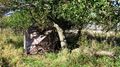
When I checked the area hash points in the morning, I was quite surprised to see that this one was 1: not in Wisconsin, and 2: in a forest preserve, meaning public lands. I debated whether or not to go when I noticed that it was about a mile from Raceway Woods, a forest preserve in Carpentersville that contains the abandoned Meadowdale Raceway. I've been wanting to go there for a few years, but could never justify the trip up from Bolingbrook. I then checked the weather and saw 78° and sunny in the forecast. That settled it, I had to go!
From the aerial photos it looked like the point was in a flood plain, so I packed an extra set of clothes, my camera gear, and my bike into my sister's van and headed out. The drive was uneventful and I arrived at the Raceway Woods parking lot off Route 31 shortly after 13:30. With so much daylight left, I decided that the hash point could wait, and headed to the front straight of the old track on my bike to do a lap. I was completely unprepared for the elevation changes. Down the front stretch I easily coasted to 40mph, navigated the downhill first turn at 35mph, which was terrifying, and couldn't pedal my way up the hill after the "esses". I couldn't ride up the hill onto the back stretch either, so I stopped to rest and take photos on the old racing surface. After a few minutes, I completed my lap (3.2 miles in 20.5 minutes!) and headed back to the van, where I guzzled the remainder of my water and considered taking a short nap before heading for the hash.
After resting up for a bit, I decided that naps were for babies and headed out on foot around 14:45. The plan was to walk down Commerce Parkway, which led into an industrial park, and off the end into the woods. That plan was shot down by a prominent "No Trespassing" sign at the end of the road. I back tracked to Route 31 and walked over to the corn field adjacent to the industrial park. The thinking was that if I walked through the brush along the border of the crops, I wouldn't technically be on industrial property, and wouldn't technically be in the field either. Before I got more than halfway down the length of the field, however, I encountered many thorns and burrs, and with my athletic shorts covered in them, decided that walking the additional mile to the hash was not a good idea. I retreated back to the van to change into the heavy jeans I had brought with.
Now making my third attempt to reach the hash, I had no problem fighting through the brush and thorns to the rear of the field where I encountered shoulder high prairie grasses. I stopped in a small clearing for a photo, then proceeded into the trees. The vegetation changed almost too quickly to photograph. Sometimes it was ankle high weeds, sometimes waist high thorn bushes. I did my best to follow wildlife trails so as to disturb the environment as little as possible. This led me past a hunting blind, and eventually a small creek, that I paralleled until I found a suitable crossing point.
Eventually, I came to a field of tall prairie grasses, and with less than 300 feet to go, I had to abandon the wildlife trails in search of the hash point. I did what I can assume is the standard GPS dance, and found a spot almost exactly on the hash coordinates at 16:20. I took some photos with my hashfox Collin, and began to follow the GPS route back towards the road. I found a fallen tree over which I was able to cross the creek, and followed the ever lowering sun back to the corn field. Despite feeling dehydrated, which I later cured at a gas station on the way home, I made it back to the van having thoroughly enjoyed my first geohashing adventure!
Photos
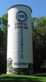
The restored silo at Raceway Woods
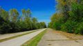
Meadowdale Raceway front straight
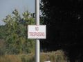
Can't go any farther
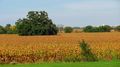
Amber waves of corn?
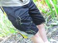
Shorts wont help you here
The hunting blind
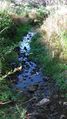
In suburbia, a natural creekbed is a rare sight
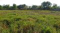
View from the hash point
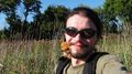
Me and Collin at the hash
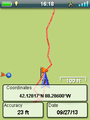
Coordinates reached!


Achievements
Mystrsyko earned the Land geohash achievement
|