Difference between revisions of "2013-10-27 41 -89"
From Geohashing
imported>Michael5000 m (→Tracklog) |
imported>Michael5000 m (→Plans) |
||
| Line 24: | Line 24: | ||
* [[User:Michael5000|Michael5000]] -- Expedition #151 | * [[User:Michael5000|Michael5000]] -- Expedition #151 | ||
| − | |||
| − | |||
| − | |||
== Expedition == | == Expedition == | ||
Revision as of 04:47, 8 June 2019
| Sun 27 Oct 2013 in 41,-89: 41.7883884, -89.0978016 geohashing.info google osm bing/os kml crox |
Location
On Lee Road, north of US 30 and west of state road 251.
Participants
- Michael5000 -- Expedition #151
Expedition
Since I was driving back into Chicago from the west, it was a no-brainer to pluck this road-accessible hashpoint just a few miles off the highway. I stopped the car exactly on the hashpoint, took a few pictures of the expansive agricultural landscape, and then continued on my way.
Photos
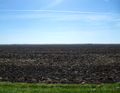
View from the hashpoint looking south.
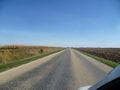
View east along Lee Road.
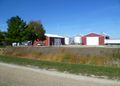
View northwest at a nearby farmstead.
.JPG)
.JPG)
.JPG)
Achievements
I have now geohashed in Oregon, Washington, Colorado, Idaho, Wyoming (unsuccessfully), Montana, Maine, Iowa, and Illinois.
Michael5000 earned the Multihash Achievement
|