Difference between revisions of "2013-10-16 33 -82"
From Geohashing
imported>Tomkf61 (→Photos) |
imported>Tomkf61 (→Photos) |
||
| Line 40: | Line 40: | ||
File:2013 10 16 33 -82 01 nearest landmark bridge.jpg | Landmark bridge | File:2013 10 16 33 -82 01 nearest landmark bridge.jpg | Landmark bridge | ||
| − | File:2013 10 16 33 -82 02 view of stream.jpg | | + | File:2013 10 16 33 -82 02 view of stream.jpg | Millstone Creek |
File:2013 10 16 33 -82 03 hash location 01.jpg | Hash location | File:2013 10 16 33 -82 03 hash location 01.jpg | Hash location | ||
File:2013 10 16 33 -82 04 marked spot.jpg | Hash marked | File:2013 10 16 33 -82 04 marked spot.jpg | Hash marked | ||
Revision as of 08:18, 4 November 2013
| Wed 16 Oct 2013 in 33,-82: 33.9923051, -82.9567351 geohashing.info google osm bing/os kml crox |
Location
Approximately 35 meters SW of Gene Smith Road, about half-way between Thompson Lane and Millstone Church Road, in Oglethorpe County, Georgia, USA
Participants
Plans
I have been watching the inactive Evans, GA graticule for some time for an opportunity to visit. I had the day off from work and it so happened that the hash for the day was close to the town of Athens, GA. I decided to try for the hash and then have dinner with my daughter, who lives in Athens, on the way home.
Expedition
Photos
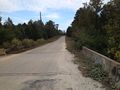
Landmark bridge
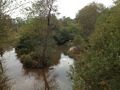
Millstone Creek
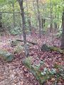
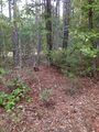
Hash location

Hash marked
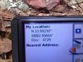
Shot of GPS
View from hash to road
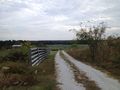
A lovely farm
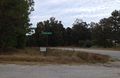
Nearest (marked) intersection
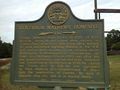
Historical Marker


