Difference between revisions of "2013-12-25 33 -117"
From Geohashing
imported>LucasBrown (Map at hashpoint) |
imported>LucasBrown (A plank bridge over a creek near the hashpoint [http://www.openstreetmap.org/?lat=33.06890000&lon=-117.08300000&zoom=16&layers=B000FTF @33.0689,-117.0830]) |
||
| Line 42: | Line 42: | ||
Image:2013-12-25_33_-117_14-39-47-774.jpg | Map at hashpoint | Image:2013-12-25_33_-117_14-39-47-774.jpg | Map at hashpoint | ||
| + | |||
| + | Image:2013-12-25_33_-117_14-40-37-292.jpg | A plank bridge over a creek near the hashpoint [http://www.openstreetmap.org/?lat=33.06890000&lon=-117.08300000&zoom=16&layers=B000FTF @33.0689,-117.0830] | ||
</gallery> | </gallery> | ||
Revision as of 22:40, 25 December 2013
| Wed 25 Dec 2013 in 33,-117: 33.0694823, -117.0841345 geohashing.info google osm bing/os kml crox |
Location
Participants
Plans
Expedition
Tracklog
Photos
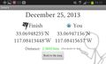
Geohash Droid details page at the hashpoint
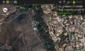
Map at hashpoint
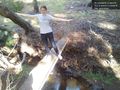
A plank bridge over a creek near the hashpoint @33.0689,-117.0830


Achievements