Difference between revisions of "2014-01-12 38 -121"
imported>LeslieHapablap (Trying to use the template, afterwards will copy the content into the sections) |
imported>LeslieHapablap (Hopefully everything is ok :)) |
||
| Line 19: | Line 19: | ||
== Location == | == Location == | ||
<!-- where you've surveyed the hash to be --> | <!-- where you've surveyed the hash to be --> | ||
| − | + | Between the PKA Fraternity House and Elmwood Street, Davis, CA, USA. | |
== Participants == | == Participants == | ||
<!-- who attended: If you link to your wiki user name in this section, your expedition will be picked up by the various statistics generated for geohashing. You may use three tildes ~ as a shortcut to automatically insert the user signature of the account you are editing with. | <!-- who attended: If you link to your wiki user name in this section, your expedition will be picked up by the various statistics generated for geohashing. You may use three tildes ~ as a shortcut to automatically insert the user signature of the account you are editing with. | ||
--> | --> | ||
| − | + | [[User:Chandru|Chandru]] | |
| − | |||
| − | |||
== Expedition == | == Expedition == | ||
<!-- how it all turned out. your narrative goes here. --> | <!-- how it all turned out. your narrative goes here. --> | ||
| + | It's been WAY too long since I've last attempted a hash. The last time I wrote up a report was almost a year ago. On a whim I checked the coordinate calculator Saturday night, and saw that the hashpoint was extremely close to everything. It was just one mile from my house, so I could easily get there. I had planned to bike, but it was too windy. Thankfully, since this place was so convienently located, I was able to take the bus there! The bus stop was close to the hashpoint (~0.1 miles). After I exited the bus, I walked down Russell Boulevard towards the hashpoint. | ||
| − | + | Now is the time where I should mention that I just got an iPhone (yeah, I know). As a result, I can no longer use Geohash Droid. I found a geohash app, but it isn't as accurate as the amazing Android application. It doesn't tell me how close I am, beyond tenths of a mile. As I recall, successful geohashes require me to be within 50 feet of the hashpoint. So, I had to guess. | |
| − | |||
| + | I could tell on Google Maps that the hashpoint was behind the Pi Kappa Alpha frat house. Being someone who was spending a Sunday afternoon geohashing, I felt I didn't belong in such a place. At this point, I noticed a sign that read "Elm Street." Instead of being an actual road, it appeared to simply be a gravel driveway. Upon closer look, there was a small paved path that was only big enough for pedestrians and bikes. I entered the path, and exited on a different street, called Elmwood Drive. Why Davis city planners decided to connect Elm and Elmwood remains a mystery to me. Elmwood Drive is a quiet street, as opposed to the arterial Rusell Blvd. I went to a small cul-de-sac close to the hashpoint, and took my picture there. | ||
== Photos == | == Photos == | ||
<!-- Insert pictures between the gallery tags using the following format: | <!-- Insert pictures between the gallery tags using the following format: | ||
Image:2012-##-## ## ## Alpha.jpg | Witty Comment | Image:2012-##-## ## ## Alpha.jpg | Witty Comment | ||
--> | --> | ||
| − | <gallery perrow=" | + | <gallery perrow="4"> |
| + | Image:2014_01_12_bus.jpg|On the bus! | ||
| + | Image:2014_01_12_selfie.jpg|At the hashpoint! | ||
| + | Image:2014_01_12_map.jpg|The closest I got to the hashpoint. | ||
</gallery> | </gallery> | ||
| + | The photo editor was being weird, so I instagrammed the other photos! | ||
| + | http://instagram.com/p/jGZnDdR-oe/# (Frat house) | ||
| + | http://instagram.com/p/jGZKykR-oP/# (That cool path) | ||
== Achievements == | == Achievements == | ||
{{#vardefine:ribbonwidth|800px}} | {{#vardefine:ribbonwidth|800px}} | ||
<!-- Add any achievement ribbons you earned below, or remove this section --> | <!-- Add any achievement ribbons you earned below, or remove this section --> | ||
| − | + | {{Public transport geohash | |
| + | | latitude = 38 | ||
| + | | longitude = -121 | ||
| + | | date = 2014-01-12 | ||
| + | | busline = Unitrans | ||
| + | | name = Chandru | ||
| + | | image = 2014_01_12_bus.jpg | ||
| + | }} | ||
<!-- =============== USEFUL CATEGORIES FOLLOW ================ | <!-- =============== USEFUL CATEGORIES FOLLOW ================ | ||
Delete the next line ONLY if you have chosen the appropriate categories below. If you are unsure, don't worry. People will read your report and help you with the classification. --> | Delete the next line ONLY if you have chosen the appropriate categories below. If you are unsure, don't worry. People will read your report and help you with the classification. --> | ||
| − | |||
<!-- Potential categories. Please include all the ones appropriate to your expedition --> | <!-- Potential categories. Please include all the ones appropriate to your expedition --> | ||
| Line 84: | Line 95: | ||
| − | |||
| − | |||
| − | |||
| − | |||
| − | |||
| − | |||
| − | |||
| − | |||
| − | |||
| − | |||
| − | |||
| − | |||
| − | |||
| − | |||
| − | |||
| − | |||
| − | |||
| − | |||
| − | |||
| − | |||
| − | |||
| − | |||
| − | |||
| − | |||
| − | |||
| − | |||
| − | |||
| − | |||
[[Category:Coordinates reached]] | [[Category:Coordinates reached]] | ||
[[Category:Expeditions]] | [[Category:Expeditions]] | ||
[[Category:Expeditions with photos]] | [[Category:Expeditions with photos]] | ||
Revision as of 12:56, 13 January 2014
| Sun 12 Jan 2014 in 38,-121: 38.5469398, -121.7559078 geohashing.info google osm bing/os kml crox |
Location
Between the PKA Fraternity House and Elmwood Street, Davis, CA, USA.
Participants
Expedition
It's been WAY too long since I've last attempted a hash. The last time I wrote up a report was almost a year ago. On a whim I checked the coordinate calculator Saturday night, and saw that the hashpoint was extremely close to everything. It was just one mile from my house, so I could easily get there. I had planned to bike, but it was too windy. Thankfully, since this place was so convienently located, I was able to take the bus there! The bus stop was close to the hashpoint (~0.1 miles). After I exited the bus, I walked down Russell Boulevard towards the hashpoint.
Now is the time where I should mention that I just got an iPhone (yeah, I know). As a result, I can no longer use Geohash Droid. I found a geohash app, but it isn't as accurate as the amazing Android application. It doesn't tell me how close I am, beyond tenths of a mile. As I recall, successful geohashes require me to be within 50 feet of the hashpoint. So, I had to guess.
I could tell on Google Maps that the hashpoint was behind the Pi Kappa Alpha frat house. Being someone who was spending a Sunday afternoon geohashing, I felt I didn't belong in such a place. At this point, I noticed a sign that read "Elm Street." Instead of being an actual road, it appeared to simply be a gravel driveway. Upon closer look, there was a small paved path that was only big enough for pedestrians and bikes. I entered the path, and exited on a different street, called Elmwood Drive. Why Davis city planners decided to connect Elm and Elmwood remains a mystery to me. Elmwood Drive is a quiet street, as opposed to the arterial Rusell Blvd. I went to a small cul-de-sac close to the hashpoint, and took my picture there.
Photos
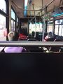
On the bus!

At the hashpoint!
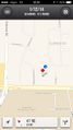
The closest I got to the hashpoint.


The photo editor was being weird, so I instagrammed the other photos! http://instagram.com/p/jGZnDdR-oe/# (Frat house) http://instagram.com/p/jGZKykR-oP/# (That cool path)
Achievements
Chandru earned the Public transport geohash achievement
|