Difference between revisions of "2014-03-07 51 13"
From Geohashing
imported>Oisín |
imported>Oisín (Report) |
||
| Line 27: | Line 27: | ||
== Plans == | == Plans == | ||
| − | + | Since I first heard of Geohashing in November I hoped to get a location that was close to my normal ways to and from work. The first time the hash was close enough I didn't have the time to visit the location. Today I had some time to try my first expedition. | |
== Expedition == | == Expedition == | ||
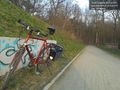
| − | + | The weather was unusually warm for march and the sun was shining. It only took a small detour on my way home from work through a forest area in the north of Dresden. I parked my bike close to the location and enjoyed the sun. -- [[User:Oisín|Oisín]] [http://www.openstreetmap.org/?lat=51.10835133&lon=13.69360289&zoom=16 @51.1084,13.6936] 16:57, 7 March 2014 (CET) | |
| − | + | <!-- == Tracklog == | |
| − | + | if your GPS device keeps a log, you may post a link here --> | |
| − | == Tracklog == | ||
| − | |||
== Photos == | == Photos == | ||
| Line 49: | Line 47: | ||
<!-- =============== USEFUL CATEGORIES FOLLOW ================ | <!-- =============== USEFUL CATEGORIES FOLLOW ================ | ||
Delete the next line ONLY if you have chosen the appropriate categories below. If you are unsure, don't worry. People will read your report and help you with the classification.--> | Delete the next line ONLY if you have chosen the appropriate categories below. If you are unsure, don't worry. People will read your report and help you with the classification.--> | ||
| − | [[Category:New report]] | + | <!-- [[Category:New report]] --> |
<!-- ==REQUEST FOR TWITTER BOT== Please leave either the New report or the Expedition planning category in as long as you work on it. This helps the twitter bot a lot with announcing the right outcome at the right moment. --> | <!-- ==REQUEST FOR TWITTER BOT== Please leave either the New report or the Expedition planning category in as long as you work on it. This helps the twitter bot a lot with announcing the right outcome at the right moment. --> | ||
| Line 65: | Line 63: | ||
[[Category:Expedition without GPS]] | [[Category:Expedition without GPS]] | ||
--> | --> | ||
| − | + | [[Category:Expeditions with photos]] | |
| − | <!-- if you reached your coords: | + | |
| + | <!-- if you reached your coords: --> | ||
[[Category:Coordinates reached]] | [[Category:Coordinates reached]] | ||
| − | |||
| − | |||
| − | |||
| − | |||
| − | |||
| − | |||
| − | |||
| − | |||
| − | |||
| − | |||
| − | |||
| − | |||
| − | |||
| − | |||
| − | |||
| − | |||
| − | |||
| − | |||
Revision as of 07:04, 10 March 2014
| Fri 7 Mar 2014 in 51,13: 51.1083237, 13.6936191 geohashing.info google osm bing/os kml crox |
Location
A small footpath at the border between the city of Dresden and Radebeul.
Participants
Plans
Since I first heard of Geohashing in November I hoped to get a location that was close to my normal ways to and from work. The first time the hash was close enough I didn't have the time to visit the location. Today I had some time to try my first expedition.
Expedition
The weather was unusually warm for march and the sun was shining. It only took a small detour on my way home from work through a forest area in the north of Dresden. I parked my bike close to the location and enjoyed the sun. -- Oisín @51.1084,13.6936 16:57, 7 March 2014 (CET)
Photos
The place @51.1083,13.6936
