Difference between revisions of "2014-03-14 51 12"
imported>TFTD (→Photos) |
imported>TFTD (Expedition story) |
||
| Line 32: | Line 32: | ||
== Expedition == | == Expedition == | ||
<!-- how it all turned out. your narrative goes here. --> | <!-- how it all turned out. your narrative goes here. --> | ||
| + | I started my expedition around noon in pure sunshine and was making good progress. I came by the lokal power station and took a picture. I ones was actually inside that thing. Ones in Merseburg I had to slow down a little to not loose my way. I finally reached Bad Dürrenberg and by accident came by the graduation tower, which I never knew was there. Since I wanted to reach the hash I didn't spend to much time, just took some pictures and moved one. Shortly before I reached the hash I lost my way little bit and decided to ask my GPS where I was. Unfortunatly I had to realize that my phone was powered off. That is a bad sign, because that normally means the battery decided to fail. I tried to turn it back on and ones it was up i started my GPS and in that moment the phone failed again. | ||
| + | I was a little pissed but decided to at least visit the hash anyway. Using my orientation skills I at least found the field and had to realize that the farmer possessing that field was actually working on it. So I stood there for a while deciding what to do and finally the farmer left. I tried to power my phone again and my surprise it booted all the way and I could start the GPS. I turned off the screen to save battery and run to the place where I suspected the coordinates. Got my camera ready, turned on my phone, waited for a GPS connection and took a picture. For that the coordinates fit pretty good I think. | ||
| + | It was about 2:30pm by then and I was hungry so I ate something at a bus station close by. On my way back I decided to follow the Saale River Bike Trail. I came by an funny sign saying welcome to the garden and industry city of Leune which I thought is funny. The area is full with big chemistry factories so I think the sign is quite ironic. Paint it green. :) Also most of my path was parallel to one of the longest tram lines in the world, I think it takes about 2 hours to get from one and to the other when taking it. | ||
| + | Than I decided to visit some friends, so I didn't come back home till 10:30pm and had a total roundtrip of about 75 to 80km. Fun and nice day, and mission accomplished. | ||
== Tracklog == | == Tracklog == | ||
| Line 65: | Line 69: | ||
<!-- ==REQUEST FOR TWITTER BOT== Please leave either the New report or the Expedition planning category in as long as you work on it. This helps the twitter bot a lot with announcing the right outcome at the right moment. --> | <!-- ==REQUEST FOR TWITTER BOT== Please leave either the New report or the Expedition planning category in as long as you work on it. This helps the twitter bot a lot with announcing the right outcome at the right moment. --> | ||
| − | |||
| − | |||
| − | |||
| − | |||
[[Category:Expeditions]] | [[Category:Expeditions]] | ||
| − | |||
[[Category:Expeditions with photos]] | [[Category:Expeditions with photos]] | ||
| − | |||
| − | |||
| − | |||
| − | |||
| − | |||
[[Category:Coordinates reached]] | [[Category:Coordinates reached]] | ||
| − | |||
| − | |||
| − | |||
| − | |||
| − | |||
| − | |||
| − | |||
| − | |||
| − | |||
| − | |||
| − | |||
| − | |||
| − | |||
| − | |||
| − | |||
| − | |||
| − | |||
| − | |||
Revision as of 12:01, 15 March 2014
| Fri 14 Mar 2014 in 51,12: 51.2742678, 12.1086302 geohashing.info google osm bing/os kml crox |
Location
It is on a field south of Ragwitz.
Participants
Plans
If the weather stays as it was the last days I plan for a bike ride from the western part of Halle to the place and back.
Expedition
I started my expedition around noon in pure sunshine and was making good progress. I came by the lokal power station and took a picture. I ones was actually inside that thing. Ones in Merseburg I had to slow down a little to not loose my way. I finally reached Bad Dürrenberg and by accident came by the graduation tower, which I never knew was there. Since I wanted to reach the hash I didn't spend to much time, just took some pictures and moved one. Shortly before I reached the hash I lost my way little bit and decided to ask my GPS where I was. Unfortunatly I had to realize that my phone was powered off. That is a bad sign, because that normally means the battery decided to fail. I tried to turn it back on and ones it was up i started my GPS and in that moment the phone failed again. I was a little pissed but decided to at least visit the hash anyway. Using my orientation skills I at least found the field and had to realize that the farmer possessing that field was actually working on it. So I stood there for a while deciding what to do and finally the farmer left. I tried to power my phone again and my surprise it booted all the way and I could start the GPS. I turned off the screen to save battery and run to the place where I suspected the coordinates. Got my camera ready, turned on my phone, waited for a GPS connection and took a picture. For that the coordinates fit pretty good I think. It was about 2:30pm by then and I was hungry so I ate something at a bus station close by. On my way back I decided to follow the Saale River Bike Trail. I came by an funny sign saying welcome to the garden and industry city of Leune which I thought is funny. The area is full with big chemistry factories so I think the sign is quite ironic. Paint it green. :) Also most of my path was parallel to one of the longest tram lines in the world, I think it takes about 2 hours to get from one and to the other when taking it. Than I decided to visit some friends, so I didn't come back home till 10:30pm and had a total roundtrip of about 75 to 80km. Fun and nice day, and mission accomplished.
Tracklog
Photos
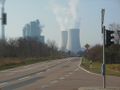
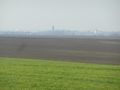
A powerstation near Schkopau along the way.
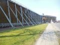
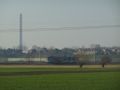
A graduation tower in Bad Dürrenberg, I never knew was there.
A close-up of the graduation tower.
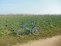
My bike in front of the field with the hash. In the background you can see the farmer.
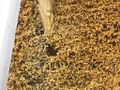
Areal picture taken while waiting for the farmer to leave his field.
Coordinate proof.
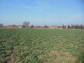
Picture standing on the coordinates towards Ragwitz.
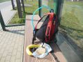
Finally some food!
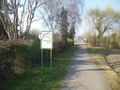
A funny sign stating that you are welcome to the industry and garden city of Leuna.
On of the longest tram lines in the world at work.
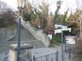
A Camino de Satniago de Compostela crossing my path.


