Difference between revisions of "2014-03-19 50 -113"
From Geohashing
imported>Guzzby (→Expedition) |
imported>Guzzby (→Achievements) |
||
| Line 48: | Line 48: | ||
{{#vardefine:ribbonwidth|800px}} | {{#vardefine:ribbonwidth|800px}} | ||
<!-- Add any achievement ribbons you earned below, or remove this section --> | <!-- Add any achievement ribbons you earned below, or remove this section --> | ||
| + | {{Speed racer | ||
| + | | latitude = 50 | ||
| + | | longitude = -113 | ||
| + | | date = 2014-03 | ||
| + | | name = * [[User:Guzzby|Guzzby]] | ||
| + | | speed = 110 km/hour | ||
| + | |||
| + | }} | ||
<!-- =============== USEFUL CATEGORIES FOLLOW ================ | <!-- =============== USEFUL CATEGORIES FOLLOW ================ | ||
Revision as of 23:46, 19 March 2014
| Wed 19 Mar 2014 in 50,-113: 50.7301161, -113.8867846 geohashing.info google osm bing/os kml crox |
Location
East of Okotoks, AB In the middle of the southbound lane of Highway 2
Participants
Plans
Plan to drive over this location at 100 Km/Hour. The current posted speed limit. Will be going out there around 2:00 pm today.
Expedition
Left the house at 2:00. Reached ground zero around 2:30. Picked up four geocaches while in the area.
Photos
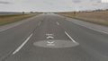
Ground Zero
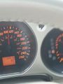
Speedometer


Achievements
|