Difference between revisions of "2014-05-11 48 16"
imported>G* (→Photos) |
imported>G* (→Photos: gallery syntax) |
||
| Line 34: | Line 34: | ||
== Photos == | == Photos == | ||
| − | + | <gallery> | |
| − | + | Image: 2014-05-11_14.53.56.jpg|Start of trip: crossing the Danube | |
| − | + | Image: 2014-05-11_16.58.24.jpg|20m to target: Lagerhaus on north side of street | |
| − | + | Image: 2014-05-11_16.58.32.jpg|OMV, south side | |
| − | + | </gallery> | |
| − | |||
| − | |||
| − | |||
| − | |||
[[Category:Expeditions]] | [[Category:Expeditions]] | ||
[[Category:Expeditions with photos]] | [[Category:Expeditions with photos]] | ||
[[Category:Coordinates reached]] | [[Category:Coordinates reached]] | ||
Revision as of 23:01, 17 May 2014
| Sun 11 May 2014 in 48,16: 48.3660545, 16.6435646 geohashing.info google osm bing/os kml crox |
Contents
Location
Near Gänserndorf, in the Marchfeld.
Participants
Plans
The Vienna geohash for Sunday is in the middle of a road, some 30 km from Vienna. User:G* plans to go there.
Expedition
I checked out one of Vienna's "citybikes" around 14:45 at the Praterstern station. I thought I could do the 30km to the hashpoint quickly, but the constant rain, interrupted only by occasional drizzle, made the ride a bit unpleasant, so it took me more than 2 hours to get there.
The hashpoint itself is in the middle of the road. By the time I got there, my fingers were not dry enough to operate the touchscreen of my cellphone, but I still managed to take 2 pictures (Lagerhaus in the north, OMV on the south side of the street). I used "mytracks" to document my trip: https://drive.google.com/file/d/0B6FwB6Orvmq7U0l0bzQxRnRJZWM
The way back was only 20km, as I only went to Leopoldau, the easternmost stop of Vienna's subway line U1.
Photos
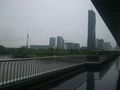
Start of trip: crossing the Danube
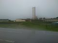
20m to target: Lagerhaus on north side of street
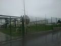
OMV, south side


