Difference between revisions of "2014-05-12 50 8"
From Geohashing
imported>Yakamoz (→Plans) |
imported>Yakamoz (→Photos) |
||
| Line 24: | Line 24: | ||
== Photos == | == Photos == | ||
<gallery perrow="5"> | <gallery perrow="5"> | ||
| − | Image:2014-05-12_50_8_Rincewind_1399908942292.jpg | Next to the geohash. A typical German Fachwerkhaus | + | Image:2014-05-12_50_8_Rincewind_1399908942292.jpg | Next to the geohash. A typical German Fachwerkhaus (a timbered house) |
Image:2014-05-12_50_8_Rincewind_1399909153000.jpg | Coordinates reached | Image:2014-05-12_50_8_Rincewind_1399909153000.jpg | Coordinates reached | ||
Image:2014-05-12_50_8_Rincewind_1399909202686.jpg | Yay! | Image:2014-05-12_50_8_Rincewind_1399909202686.jpg | Yay! | ||
Revision as of 20:05, 13 May 2014
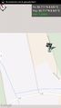
| Mon 12 May 2014 in 50,8: 50.7105412, 8.6512221 geohashing.info google osm bing/os kml crox |
Location
Between Giessen and Marburg, very close to B3 (federal road 3)
Participants
Plans
To use a sunny spell during April showers in May...
Expedition
This geohash was very easy to reach. We drove with Rincewinds car the federal road and had 50m to walk. A short trip was sucessful.
Tracklog
Photos
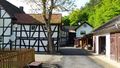
Next to the geohash. A typical German Fachwerkhaus (a timbered house)
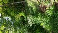
Coordinates reached

Yay!
Geohash track


Achievements
Land