Difference between revisions of "2014-08-30 50 8"
From Geohashing
imported>Mampfred |
imported>Mampfred (→Photos) |
||
| Line 29: | Line 29: | ||
Image:2014-08-30_50_8_on_the_way.jpg | Nice day for a walk | Image:2014-08-30_50_8_on_the_way.jpg | Nice day for a walk | ||
Image:2014-08-30_50_8_coordinates_reached.jpg | Coordinates reached | Image:2014-08-30_50_8_coordinates_reached.jpg | Coordinates reached | ||
| − | Image:2014-08- | + | Image:2014-08-30_50_8_Mampfred_1409391476487.jpg | Cookies at the hash. |
Image:2014-08-30_50_8_Mampfred_1409391691592.jpg | Group shot | Image:2014-08-30_50_8_Mampfred_1409391691592.jpg | Group shot | ||
</gallery> | </gallery> | ||
Revision as of 15:28, 30 August 2014
| Sat 30 Aug 2014 in 50,8: 50.1748896, 8.3583306 geohashing.info google osm bing/os kml crox |
Location
Between Niederhausen-Oberjosbach and Eppstein-Ehlhalten right next to the street.
Participants
Plans
A whopping 1.223 km from where we live this is a must-hash. ETA unknown.
Expedition
Despite it being one of teh shortest hashes in terms of distance it was one of the longer ones in terms of time as we decided to make EmmJay walk most of the way. Nice weather, sunshine most of the way.
Tracklog
See here.
Photos
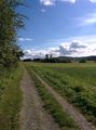
Nice day for a walk
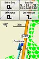
Coordinates reached

Cookies at the hash.

Group shot


