Difference between revisions of "2014-09-10 51 9"
imported>GeorgDerReisende (create page) |
imported>GeorgDerReisende (expedition report for Wolfhagen) |
||
| Line 1: | Line 1: | ||
| − | |||
| − | |||
| − | |||
| − | |||
| − | |||
| − | |||
| − | |||
| − | |||
| − | |||
| − | |||
{{meetup graticule | {{meetup graticule | ||
| lat=51 | | lat=51 | ||
| Line 15: | Line 5: | ||
}} | }} | ||
| − | |||
__NOTOC__ | __NOTOC__ | ||
== Location == | == Location == | ||
| − | + | ||
| + | The hash lied under a tree on a meadow of Wolfhagen. | ||
== Participants == | == Participants == | ||
| − | + | ||
| − | + | [[User:GeorgDerReisende|GeorgDerReisende]] | |
== Plans == | == Plans == | ||
| − | + | ||
| + | Hitchhiking and walking. | ||
== Expedition == | == Expedition == | ||
| − | |||
| − | + | I left home at 13:45 and started to hitchhike at the Wilhelmshöhe junction at 15:00. With four cars I arrived at Wolfhagen-Gasterfeld at 17:00. Then I walked to the hash. I found it easy lying on a meadow under a tree. I took the usual pictures, walked around a little bit, and walked then to Wolfhagen. There I started to hitchhike at 19:10 and with three cars (in the twilight, with low flying dark and foggy looking clouds and some drizzling rain on third level country roads) I arrived at Kassel at 19:54 and at home at 20:30! | |
| − | |||
== Photos == | == Photos == | ||
| − | |||
| − | |||
| − | |||
<gallery perrow="5"> | <gallery perrow="5"> | ||
| + | Image:2014-09-10 51 9 GeorgDerReisende 5950.jpg | The dance was at the hash. | ||
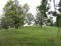
| + | Image:2014-09-10 51 9 GeorgDerReisende 5951.jpg | The last meter to find needed some time. | ||
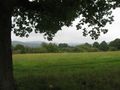
| + | Image:2014-09-10 51 9 GeorgDerReisende 5952.jpg | A deep valley at the west. | ||
| + | Image:2014-09-10 51 9 GeorgDerReisende 5953.jpg | The north. | ||
| + | Image:2014-09-10 51 9 GeorgDerReisende 5954.jpg | The east and some mountains | ||
| + | Image:2014-09-10 51 9 GeorgDerReisende 5955.jpg | The north. | ||
| + | Image:2014-09-10 51 9 GeorgDerReisende 5964.jpg | From the northern edge of the hill to see: Viesebeck. | ||
| + | Image:2014-09-10 51 9 GeorgDerReisende 5970.jpg | The geohasher and the tree. | ||
| + | Image:2014-09-10 51 9 GeorgDerReisende 6019.jpg | A street in Wolfhagen. | ||
</gallery> | </gallery> | ||
| Line 44: | Line 39: | ||
<!-- Add any achievement ribbons you earned below, or remove this section --> | <!-- Add any achievement ribbons you earned below, or remove this section --> | ||
| + | {{Thumbs Up | latitude = 51 | longitude = 9 | date = 2014-09-10 | name = GeorgDerReisende }} | ||
| − | + | [[Category:Expeditions]] | |
| − | |||
| − | [[Category: | ||
| − | + | [[Category:Expeditions with photos]] | |
| − | |||
| − | |||
| − | |||
| − | [[Category: | ||
| − | |||
| − | |||
| − | |||
| − | |||
| − | |||
| − | |||
| − | |||
| − | |||
| − | |||
| − | |||
[[Category:Coordinates reached]] | [[Category:Coordinates reached]] | ||
| − | |||
| − | |||
| − | |||
| − | |||
| − | |||
| − | |||
| − | |||
| − | |||
| − | |||
| − | |||
| − | |||
| − | |||
| − | |||
| − | |||
| − | |||
| − | |||
| − | |||
| − | |||
Revision as of 19:45, 10 September 2014
| Wed 10 Sep 2014 in 51,9: 51.3448823, 9.1413950 geohashing.info google osm bing/os kml crox |
Location
The hash lied under a tree on a meadow of Wolfhagen.
Participants
Plans
Hitchhiking and walking.
Expedition
I left home at 13:45 and started to hitchhike at the Wilhelmshöhe junction at 15:00. With four cars I arrived at Wolfhagen-Gasterfeld at 17:00. Then I walked to the hash. I found it easy lying on a meadow under a tree. I took the usual pictures, walked around a little bit, and walked then to Wolfhagen. There I started to hitchhike at 19:10 and with three cars (in the twilight, with low flying dark and foggy looking clouds and some drizzling rain on third level country roads) I arrived at Kassel at 19:54 and at home at 20:30!
Photos
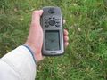
The dance was at the hash.
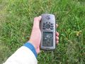
The last meter to find needed some time.
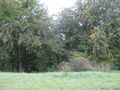
A deep valley at the west.
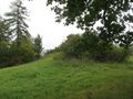
The north.
The east and some mountains
The north.
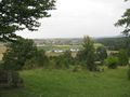
From the northern edge of the hill to see: Viesebeck.
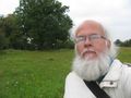
The geohasher and the tree.
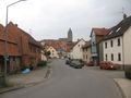
A street in Wolfhagen.


Achievements
GeorgDerReisende earned the Thumbs Up Geohash Achievement
|