Difference between revisions of "2014-09-11 51 10"
From Geohashing
imported>GeorgDerReisende (create page) |
imported>GeorgDerReisende (expedition report for Seesen) |
||
| Line 1: | Line 1: | ||
| − | |||
| − | |||
| − | |||
| − | |||
| − | |||
| − | |||
| − | |||
| − | |||
| − | |||
| − | |||
{{meetup graticule | {{meetup graticule | ||
| lat=51 | | lat=51 | ||
| Line 15: | Line 5: | ||
}} | }} | ||
| − | |||
__NOTOC__ | __NOTOC__ | ||
== Location == | == Location == | ||
| − | + | ||
| + | The hash lied 100 meters north of Seesen along the national road B248. | ||
== Participants == | == Participants == | ||
| − | + | ||
| − | + | [[User:GeorgDerReisende|GeorgDerReisende]] | |
== Plans == | == Plans == | ||
| − | + | ||
| + | Hitchhiking and walking. | ||
== Expedition == | == Expedition == | ||
| − | |||
| − | + | I left home at 11:30 and started to hitchhike at 12:30. With two cars I arrived at Seesen at 14:50. Not only that I arrived at Seesen, I arrived at the last petrol station at the northbound exit of the national road. It was 200 meters to walk to the hash. The hash lied just at a reflector post of the road. | |
| − | |||
== Photos == | == Photos == | ||
| − | |||
| − | |||
| − | |||
<gallery perrow="5"> | <gallery perrow="5"> | ||
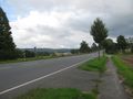
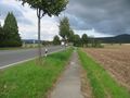
| + | Image:2014-09-11 51 10 GeorgDerReisende 6057.jpg | Arrived at Seesen, 200 meters to the hash. | ||
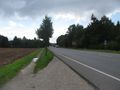
| + | Image:2014-09-11 51 10 GeorgDerReisende 6062.jpg | The near reflector post marks the hash. | ||
| + | Image:2014-09-11 51 10 GeorgDerReisende 6068.jpg | Proof. | ||
| + | Image:2014-09-11 51 10 GeorgDerReisende 6074.jpg | Stupid grin. | ||
| + | Image:2014-09-11 51 10 GeorgDerReisende 6069.jpg | The north. | ||
| + | Image:2014-09-11 51 10 GeorgDerReisende 6076.jpg | The east. | ||
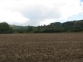
| + | Image:2014-09-11 51 10 GeorgDerReisende 6077.jpg | The west. | ||
| + | Image:2014-09-11 51 10 GeorgDerReisende 6073.jpg | The south. | ||
| + | Image:2014-09-11 51 10 GeorgDerReisende 6083.jpg | The mark. | ||
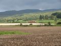
| + | Image:2014-09-11 51 10 GeorgDerReisende 6084.jpg | The situation. | ||
| + | Image:2014-09-11 51 10 GeorgDerReisende 6122.jpg | A street in Seesen. | ||
</gallery> | </gallery> | ||
== Achievements == | == Achievements == | ||
{{#vardefine:ribbonwidth|800px}} | {{#vardefine:ribbonwidth|800px}} | ||
| − | |||
| + | {{Thumbs Up | latitude = 51 | longitude = 10 | date = 2014-09-11 | name = GeorgDerReisende }} | ||
| − | + | [[Category:Expeditions]] | |
| − | |||
| − | [[Category: | ||
| − | + | [[Category:Expeditions with photos]] | |
| − | |||
| − | |||
| − | |||
| − | [[Category: | ||
| − | |||
| − | |||
| − | |||
| − | |||
| − | |||
| − | |||
| − | |||
| − | |||
| − | |||
| − | |||
[[Category:Coordinates reached]] | [[Category:Coordinates reached]] | ||
| − | |||
| − | |||
| − | |||
| − | |||
| − | |||
| − | |||
| − | |||
| − | |||
| − | |||
| − | |||
| − | |||
| − | |||
| − | |||
| − | |||
| − | |||
| − | |||
| − | |||
| − | |||
Revision as of 17:27, 11 September 2014
| Thu 11 Sep 2014 in 51,10: 51.9016011, 10.1882977 geohashing.info google osm bing/os kml crox |
Location
The hash lied 100 meters north of Seesen along the national road B248.
Participants
Plans
Hitchhiking and walking.
Expedition
I left home at 11:30 and started to hitchhike at 12:30. With two cars I arrived at Seesen at 14:50. Not only that I arrived at Seesen, I arrived at the last petrol station at the northbound exit of the national road. It was 200 meters to walk to the hash. The hash lied just at a reflector post of the road.
Photos
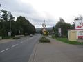
Arrived at Seesen, 200 meters to the hash.
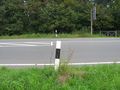
The near reflector post marks the hash.
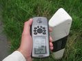
Proof.
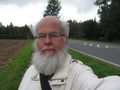
Stupid grin.
The north.
The east.
The west.
The south.
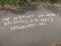
The mark.
The situation.
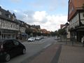
A street in Seesen.


Achievements
GeorgDerReisende earned the Thumbs Up Geohash Achievement
|