Difference between revisions of "2014-09-19 48 11"
From Geohashing
imported>DODO (→Photos) |
imported>DODO (→Achievements) |
||
| Line 55: | Line 55: | ||
{{#vardefine:ribbonwidth|800px}} | {{#vardefine:ribbonwidth|800px}} | ||
<!-- Add any achievement ribbons you earned below, or remove this section --> | <!-- Add any achievement ribbons you earned below, or remove this section --> | ||
| + | {{land geohash | ||
| + | | latitude = 48 | ||
| + | | longitude = 11 | ||
| + | | date = 2014-09-19 | ||
| + | | name = DODO | ||
| + | }} | ||
| − | |||
| − | |||
| − | |||
| − | |||
| − | |||
| − | |||
| − | |||
| − | |||
| − | |||
| − | |||
| − | |||
[[Category:Expeditions]] | [[Category:Expeditions]] | ||
| − | |||
[[Category:Expeditions with photos]] | [[Category:Expeditions with photos]] | ||
| − | |||
| − | |||
| − | |||
| − | |||
| − | |||
[[Category:Coordinates reached]] | [[Category:Coordinates reached]] | ||
| − | |||
| − | |||
| − | |||
| − | |||
| − | |||
| − | |||
| − | |||
| − | |||
| − | |||
| − | |||
| − | |||
| − | |||
| − | |||
| − | |||
| − | |||
| − | |||
| − | |||
| − | |||
Revision as of 19:57, 5 October 2014
| Fri 19 Sep 2014 in 48,11: 48.8867517, 11.6346360 geohashing.info google osm bing/os kml crox |
Location
At the edge of the forest on a field near Altmannstein.
Participants
Plans
I had to drive to Kehlheim and wondered if there are any hashes on the way. This one was the nearest, so I decided to visit it.
Expedition
On my first approach I missed a place, where I coluld leave my car, and there was no possibility to turn around until Altmannstein. But after that I found a path into the forest, and from there it was just 500m to walk. I took some photos, went back to the car and drove on.
Tracklog
Photos
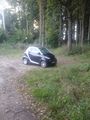
where I left little car
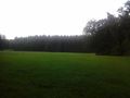
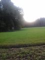
If I'm lucky, the hash is on this meadow
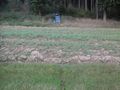
Oh no, 5 m into the mud. But it's dry at least.
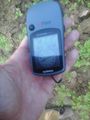
proof
proof 2
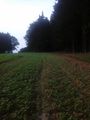
view from the hash along the field
where I come from

stupid grin


Achievements
DODO earned the Land geohash achievement
|