Difference between revisions of "2014-11-03 49 9"
From Geohashing
imported>Chemluth |
imported>Chemluth |
||
| Line 18: | Line 18: | ||
== Expedition == | == Expedition == | ||
| − | We drove to the hash since the weather wasn´t that good. | + | We drove to the hash since the weather wasn´t that good. We reached the hash at about 18:00 at the side of a road in front of the entrance to a undergrond military depot. There was a fence with a sign "Military savety zone. Trespassing forbidden. Warning: Use of firearms". So if the hash would have been 3 meters further west, we would have had a problem. |
| Line 26: | Line 26: | ||
Image:2014-11-03 49 9 chemluth 0001.JPG | The sign near the hashpoint | Image:2014-11-03 49 9 chemluth 0001.JPG | The sign near the hashpoint | ||
Image:2014-11-03 49 9 chemluth 0002.JPG | Coordinates reached | Image:2014-11-03 49 9 chemluth 0002.JPG | Coordinates reached | ||
| + | </gallery> | ||
Revision as of 14:04, 5 November 2014
| Mon 3 Nov 2014 in 49,9: 49.3296737, 9.1449406 geohashing.info google osm bing/os kml crox |
Contents
Location
On a road in Neckarzimmern near Mosbach.
Participants
Plans
I want to visit this point with some friends at about 18:00.
Expedition
We drove to the hash since the weather wasn´t that good. We reached the hash at about 18:00 at the side of a road in front of the entrance to a undergrond military depot. There was a fence with a sign "Military savety zone. Trespassing forbidden. Warning: Use of firearms". So if the hash would have been 3 meters further west, we would have had a problem.
Photos
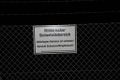
The sign near the hashpoint
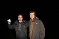
Coordinates reached

