Difference between revisions of "2014-11-16 44 11"
imported>Kleon |
imported>Kleon |
||
| Line 20: | Line 20: | ||
<!-- where you've surveyed the hash to be --> | <!-- where you've surveyed the hash to be --> | ||
| − | In the middle of a forest near Sant Apollinare, a small town on the border between Emilia-Romagna and Tuscany. | + | In the middle of a forest near Sant'Apollinare, a small town on the border between Emilia-Romagna and Tuscany. |
== Participants == | == Participants == | ||
| Line 26: | Line 26: | ||
--> | --> | ||
| − | [[User:Kleon|Kleon]] | + | [[User:Kleon|Kleon]] and a friend of mine who might create an account soon. This was the first geohash for both of us. |
== Expedition == | == Expedition == | ||
<!-- how it all turned out. your narrative goes here. --> | <!-- how it all turned out. your narrative goes here. --> | ||
| − | At 9:30 in the morning we planned the trip and after meeting and messing with maps and various GPS devices we finally left Bologna towards the nearest hashpoint. An uneventful car ride brought us to Casola Valsenio (apparently there are too many places named after Sant'Apollinare) and we kept travelling along the river for a few kilometers. We left the car near a bar roughly a | + | At 9:30 in the morning we planned the trip and after meeting and messing with maps and various GPS devices for half an hour, we finally left Bologna towards the nearest hashpoint. An uneventful car ride brought us to Casola Valsenio (apparently there are too many places named after Sant'Apollinare) and we kept travelling along the river for a few kilometers. We left the car near a bar roughly a few kilometers away from our hash. From then on we walked up the hills at fields' border or inside the forest until we got to the hash. Geohash reached at 15:00. |
== Tracklog == | == Tracklog == | ||
| Line 39: | Line 39: | ||
== Photos == | == Photos == | ||
| − | <! | + | |
| − | Image: | + | [[User:Kleon|Kleon]] took a ton of photos and uploaded only a very small portion of them. Many were discarded. Only the fittest survived to summarize our journey... |
| − | + | ||
| − | + | <gallery perrow="8"> | |
| + | Image:2014_11_16_44_11_river.jpg|This is the Senio, our geohash was on the other side of it, but nothing could stop us and our trusty bridge! | ||
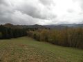
| + | Image:2014_11_16_44_11_field01.jpg|this is the first field with an abandoned old brick house. We found three of those along the path. also we ate here. | ||
| + | Image:2014_11_16_44_11_field02.jpg|A little further on, the panorama and a wild Alberto! | ||
| + | Image:2014_11_16_44_11_forest01.jpg|This is a chestnut tree forest with soft moss on the ground. | ||
| + | Image:2014_11_16_44_11_forest03.jpg|Deeper inside the forest... | ||
| + | Image:2014_11_16_44_11_forest02.jpg|...and out of it! | ||
| + | Image:2014_11_16_44_11_stupid_grin.jpg|us at the geohash featuring the stupid grin™ | ||
| + | Image:2014_11_16_44_11_gps_at_geohash.JPG|And this is the photo of Alberto's GPS device, while at the geohash. | ||
</gallery> | </gallery> | ||
| − | |||
| − | |||
== Achievements == | == Achievements == | ||
| Line 51: | Line 57: | ||
<!-- Add any achievement ribbons you earned below, or remove this section --> | <!-- Add any achievement ribbons you earned below, or remove this section --> | ||
| − | In theory this is the first hash in our grid. In practice I will gather proof before claiming any achievements | + | In theory this is the first hash in our grid. In practice I will gather proof before claiming any achievements. |
| + | I am not sure if the gps photo will count as proof but I planned very poorly and relied a little too much on our smartphones and they didn't work in the middle of a forest. oops! | ||
<!-- =============== USEFUL CATEGORIES FOLLOW ================ | <!-- =============== USEFUL CATEGORIES FOLLOW ================ | ||
| Line 67: | Line 74: | ||
[[Category:Expeditions]] | [[Category:Expeditions]] | ||
[[Category:Coordinates reached]] | [[Category:Coordinates reached]] | ||
| + | [[Category:Expeditions with photos]] | ||
Revision as of 22:16, 18 November 2014
| Sun 16 Nov 2014 in 44,11: 44.1601714, 11.6072346 geohashing.info google osm bing/os kml crox |
Location
In the middle of a forest near Sant'Apollinare, a small town on the border between Emilia-Romagna and Tuscany.
Participants
Kleon and a friend of mine who might create an account soon. This was the first geohash for both of us.
Expedition
At 9:30 in the morning we planned the trip and after meeting and messing with maps and various GPS devices for half an hour, we finally left Bologna towards the nearest hashpoint. An uneventful car ride brought us to Casola Valsenio (apparently there are too many places named after Sant'Apollinare) and we kept travelling along the river for a few kilometers. We left the car near a bar roughly a few kilometers away from our hash. From then on we walked up the hills at fields' border or inside the forest until we got to the hash. Geohash reached at 15:00.
Tracklog
My friend's GPS kept a log and I hope he will post it here soon. But again, I'm not even sure if he will become an user.
Photos
Kleon took a ton of photos and uploaded only a very small portion of them. Many were discarded. Only the fittest survived to summarize our journey...
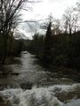
This is the Senio, our geohash was on the other side of it, but nothing could stop us and our trusty bridge!
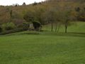
this is the first field with an abandoned old brick house. We found three of those along the path. also we ate here.
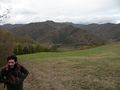
A little further on, the panorama and a wild Alberto!
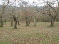
This is a chestnut tree forest with soft moss on the ground.
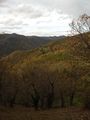
Deeper inside the forest...
...and out of it!
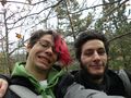
us at the geohash featuring the stupid grin™
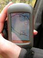
And this is the photo of Alberto's GPS device, while at the geohash.


Achievements
In theory this is the first hash in our grid. In practice I will gather proof before claiming any achievements. I am not sure if the gps photo will count as proof but I planned very poorly and relied a little too much on our smartphones and they didn't work in the middle of a forest. oops!