Difference between revisions of "2015-01-01 49 8"
From Geohashing
imported>DODO (→Achievements) |
imported>DODO (→Photos) |
||
| Line 47: | Line 47: | ||
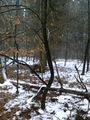
Image:2015-01-01_49_8-1.jpg|Speyrer Düne | Image:2015-01-01_49_8-1.jpg|Speyrer Düne | ||
Image:2015-01-01_49_8-2.jpg|Der Ameisenhügel (the ants hill), the highest dune in Speyer | Image:2015-01-01_49_8-2.jpg|Der Ameisenhügel (the ants hill), the highest dune in Speyer | ||
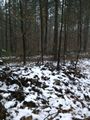
| − | Image:2015-01-01_49_8-3.jpg|I | + | Image:2015-01-01_49_8-3.jpg|I obviously left the teritory of Speyer |
Image:2015-01-01_49_8-4.jpg|proof | Image:2015-01-01_49_8-4.jpg|proof | ||
Image:2015-01-01_49_8-5.jpg|at the hashpoint | Image:2015-01-01_49_8-5.jpg|at the hashpoint | ||
Revision as of 18:28, 1 January 2015
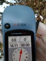
| Thu 1 Jan 2015 in 49,8: 49.3362715, 8.3794324 geohashing.info google osm bing/os kml crox |
Location
In the forest near Speyer, just 4 KM from DODOs home.
Participants
Plans
I will walk there. Start at 15:30, so I hope to arrive between 4 and 4:30.
Expedition
Just as planned: a nice 90 minutes -tron - walk to cure my hangover. I came along a place that I like very much, the Speyrer Düne (dune of Speyer).
The hash was easy to find, just 10m of my way. I took some photos, made an x with sticks (but forgot to take a picture of that) and went home. As I know the surroundings quite good, I tried a ton, and I think, I succeeded.
Tracklog
Photos
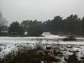
Speyrer Düne
Der Ameisenhügel (the ants hill), the highest dune in Speyer
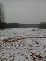
I obviously left the teritory of Speyer
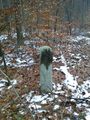
proof
at the hashpoint
the path is just a few meters from the hashpoint

stupid grin


Achievements
DODO earned the Land geohash achievement
|
DODO earned the Walk geohash Achievement
|
DODO earned the Tron achievement
|