Difference between revisions of "2015-01-21 49 8"
From Geohashing
imported>Q-Owl (→Plan) |
imported>Q-Owl |
||
| Line 22: | Line 22: | ||
== Expedition == | == Expedition == | ||
| − | |||
| − | |||
Success: | Success: | ||
| − | * I arrived at about | + | * I drove to Bickenbach after our evening meal, arrived at about 19:45 |
| − | * | + | * and found a place to park the car in the darkness 400 m away from the hp. |
| − | * | + | * When I walked along the little creek "Landbach" in the darkness I heard some splashes. |
| − | * took | + | * After switching on my torch there sat a nice big [[wikipedia:muskrat|muskrat]] (Bisam), which did not know, what to do now. |
| − | * smiled :-) | + | * I tried to take a photo with torch and smartphone. |
| − | * | + | * After this I tried to reach the hp. It was very swampy there and the groundwater level was very high. |
| − | + | * Good to find the hp at a dry place. :-) | |
| + | * I took a photo near the hash and of me, | ||
| + | * smiled, :-) | ||
| + | * walked back to the car and drove home. | ||
| + | --> | ||
== Photos == | == Photos == | ||
| − | |||
| − | |||
<gallery perrow="5" > | <gallery perrow="5" > | ||
| − | Image:2015-01-21 49 8 proof1.png | Proof | + | Image:2015-01-21 49 8 proof1.png | Proof 1 |
| − | Image:2015-01-21 49 8 proof2.png | Proof 2 | + | Image:2015-01-21 49 8 proof2.png | Proof 2 |
| − | Image:2015-01-21 49 8 | + | Image:2015-01-21 49 8 muskrat.jpg | Muskrat at te Landbach |
| − | Image:2015-01-21 49 8 | + | Image:2015-01-21 49 8 near.jpg | Little tree near the hashpoint |
| − | + | Image:2015-01-21 49 8 grin.jpg | Smile | |
| − | + | </gallery> | |
| − | |||
| − | |||
| − | |||
| − | Image:2015-01-21 49 8 grin.jpg | Smile | ||
| − | </gallery | ||
<!-- | <!-- | ||
List of uploaded Files: | List of uploaded Files: | ||
| Line 58: | Line 53: | ||
== Achievements == <!-- / Honorable Mention --> | == Achievements == <!-- / Honorable Mention --> | ||
| − | |||
{{#vardefine:ribbonwidth|600px}} | {{#vardefine:ribbonwidth|600px}} | ||
{{land geohash | {{land geohash | ||
| Line 73: | Line 67: | ||
| name = [[User:Q-Owl|Q-Owl]] | | name = [[User:Q-Owl|Q-Owl]] | ||
}} | }} | ||
| + | <!-- | ||
{{Easy_geohash | {{Easy_geohash | ||
| latitude = 49 | | latitude = 49 | ||
Revision as of 20:33, 21 January 2015
| Wed 21 Jan 2015 in 49,8: 49.7641988, 8.5937417 geohashing.info google osm bing/os kml crox |
Location
On a little meadow west of Bickenbach; not far from yesterdays hashpoint.
Participants
Plan
Todays hashpoint is not far from home and from yesterdays hashpoint. So I plan:
- Do a little detour on the way home.
- Drive to Bickenbach.
- Arrive about 17:00 19:15.
- Reach the hash point.
- Return home.
Expedition
Success:
- I drove to Bickenbach after our evening meal, arrived at about 19:45
- and found a place to park the car in the darkness 400 m away from the hp.
- When I walked along the little creek "Landbach" in the darkness I heard some splashes.
- After switching on my torch there sat a nice big muskrat (Bisam), which did not know, what to do now.
- I tried to take a photo with torch and smartphone.
- After this I tried to reach the hp. It was very swampy there and the groundwater level was very high.
- Good to find the hp at a dry place. :-)
- I took a photo near the hash and of me,
- smiled, :-)
- walked back to the car and drove home.
-->
Photos
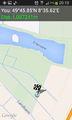
Proof 1
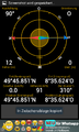
Proof 2
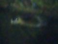
Muskrat at te Landbach
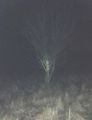
Little tree near the hashpoint
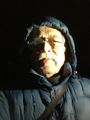
Smile


Achievements
Q-Owl earned the Land geohash achievement
|
Q-Owl earned the Consecutive geohash achievement
|