Difference between revisions of "2015-02-10 44 -122"
imported>Frogman (→Photos) |
imported>Frogman (→Achievements) |
||
| Line 48: | Line 48: | ||
{{#vardefine:ribbonwidth|800px}} | {{#vardefine:ribbonwidth|800px}} | ||
<!-- Add any achievement ribbons you earned below, or remove this section --> | <!-- Add any achievement ribbons you earned below, or remove this section --> | ||
| + | {{bicycle geohash | ||
| + | | latitude = 44 | ||
| + | | longitude = -122 | ||
| + | | date = date 2014-02-10 | ||
| + | | name = [[User:Frogman|Frogman]] | ||
| + | | distance = 42 miles | ||
| + | }} | ||
| − | |||
| − | |||
| − | |||
| − | |||
| − | |||
| − | |||
| − | |||
| − | |||
| − | |||
| − | |||
| − | |||
| − | |||
| − | |||
[[Category:Expeditions]] | [[Category:Expeditions]] | ||
| − | |||
[[Category:Expeditions with photos]] | [[Category:Expeditions with photos]] | ||
| − | |||
| − | |||
| − | |||
| − | |||
| − | |||
[[Category:Coordinates reached]] | [[Category:Coordinates reached]] | ||
| − | |||
| − | |||
| − | |||
| − | |||
| − | |||
| − | |||
| − | |||
| − | |||
| − | |||
| − | |||
| − | |||
| − | |||
| − | |||
| − | |||
| − | |||
| − | |||
| − | |||
| − | |||
Revision as of 03:17, 12 February 2015
| Tue 10 Feb 2015 in 44,-122: 44.5327025, -122.9040460 geohashing.info google osm bing/os kml crox |
Location
In downtown Lebanon, Oregon.
Participants
Plans
The funny thing about plans is that they don't always end up being followed. For example, I was planning on doing my taxes, but riding my bike to Lebanon seemed more interesting.
Expedition
I rode my bike to Lebanon. It was very flat except for the bridge over Interstate 5. In Lebanon there was a traffic light with a sensor that did not notice bicycles. The car behind me wouldn't pull up any closer to trigger the sensor, so we waited for a couple traffic cycles until I made a highly illegal maneuver and continued on my way.
On the way back home I stopped at my grandma's house. She gave me snacks! It was very nice, in part because my thighs were very sore, as I had done squats with weights previously that day.
Tracklog
Photos
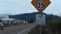
Entering Lebanon!
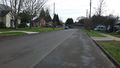
View to the south. There's a church down there.
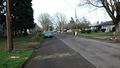
View to the north.
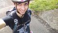
Goofy grin!


Achievements
Frogman earned the Bicycle geohash achievement
|