Difference between revisions of "2015-04-17 52 1"
From Geohashing
imported>Sourcerer m ([live] Arrived.) |
imported>Sourcerer m ([live picture] Proof. [http://www.openstreetmap.org/?lat=52.24029064&lon=1.45423472&zoom=16&layers=B000FTF @52.2403,1.4542]) |
||
| Line 22: | Line 22: | ||
== Photos == | == Photos == | ||
<gallery perrow="5"> | <gallery perrow="5"> | ||
| + | |||
| + | Image:2015-04-17_52_1_Sourcerer_1429225149011.jpg | Proof. [http://www.openstreetmap.org/?lat=52.24029064&lon=1.45423472&zoom=16&layers=B000FTF @52.2403,1.4542] | ||
</gallery> | </gallery> | ||
Revision as of 23:02, 16 April 2015
| Fri 17 Apr 2015 in 52,1: 52.2402724, 1.4541937 geohashing.info google osm bing/os kml crox |
Location
Close to a field boundary, south of Peasenhall, Suffolk, UK.
Participants
Expedition
If successful this will be expedition two of two spanning midnight - 2015-04-16 52 1 - 2015-04-17 52 1 - The points are close together.
- Arrived. -- Sourcerer (talk) @52.2403,1.4542 00:00, 17 April 2015 (GMT+01:00)
Photos
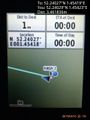
Proof. @52.2403,1.4542

Achievements
Other geohashing expeditions on the same day
Expeditions and Plans
| 2015-04-17 | ||
|---|---|---|
| Atlanta, Georgia | NWoodruff | In the parking lot of an automotive truck repair shop in Norcross. |
| Kassel, Germany | GeorgDerReisende | The hash was in the forest of Baunatal-Rengershausen. |
| Norwich, United Kingdom | Sourcerer | Close to a field boundary, south of Peasenhall, Suffolk, UK. |