Difference between revisions of "2015-05-24 48 8"
From Geohashing
imported>RecentlyChanged ([live picture] Grin (yay, upside down, I really have to fix this later) [http://www.openstreetmap.org/?lat=48.44964266&lon=8.67743969&zoom=16&layers=B000FTF @48.4496,8.6774]) |
imported>Calamus m (Categorization.) |
||
| Line 51: | Line 51: | ||
| − | |||
| − | |||
| − | |||
| − | |||
| − | |||
| − | |||
| − | |||
| − | |||
| − | |||
| − | |||
| − | |||
[[Category:Expeditions]] | [[Category:Expeditions]] | ||
| − | |||
[[Category:Expeditions with photos]] | [[Category:Expeditions with photos]] | ||
| − | |||
| − | |||
| − | |||
| − | |||
| − | |||
[[Category:Coordinates reached]] | [[Category:Coordinates reached]] | ||
| − | |||
| − | |||
| − | |||
| − | |||
| − | |||
| − | |||
| − | |||
| − | |||
| − | |||
| − | |||
| − | |||
| − | |||
| − | |||
| − | |||
| − | |||
| − | |||
| − | |||
| − | |||
Revision as of 12:41, 24 May 2015
| Sun 24 May 2015 in 48,8: 48.4497151, 8.6774815 geohashing.info google osm bing/os kml crox |
Location
Horb am Neckar
Participants
RecentlyChanged (talk) 09:54, 23 May 2015 (EDT)
Plans
I will get up really early in the morning and take the motorbike. It will be a long and beautiful tour! I try to be at the hash at around 12 pm, because I have to go on, I will visit a friend way further in the north.
Expedition
- I'll be there way earlier then I thought I will be. I started around 7 am and had a nice tour until now. Now I'm eating breakfast and thing about my plans for today. First: I have a map with me with good streets for motorbikes, I will look it up to have more fun then the big boring street I am on now.
Second: I am way earlier, I'm probably able to make the 49 8 hash too. Or the 48 9... -- RecentlyChanged (talk) @48.3128,8.5698 08:30, 24 May 2015 (CEST)
Tracklog
Photos
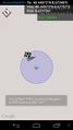
Proof! @48.4497,8.6776
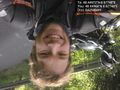
Grin (yay, upside down, I really have to fix this later) @48.4496,8.6774

