Difference between revisions of "2015-05-21 43 -85"
From Geohashing
imported>Mcbaneg (Created page with "<!-- If you did not specify these parameters in the template, please substitute appropriate values for IMAGE, LAT, LON, and DATE (YYYY-MM-DD format) {{{image|dummy.jpg}}}|...") |
imported>FippeBot m (Location) |
||
| Line 57: | Line 57: | ||
[[Category:Expeditions with photos]] | [[Category:Expeditions with photos]] | ||
[[Category:Coordinates reached]] | [[Category:Coordinates reached]] | ||
| + | {{location|US|MI|KN}} | ||
Latest revision as of 03:41, 15 August 2019

| Thu 21 May 2015 in 43,-85: 43.1082662, -85.4819748 geohashing.info google osm bing/os kml crox |
Location
hillside above a pond north of Cannonsburg, MI, USA
Participants
Expedition
Katja needs driving practice, and this looked accessible and was about 40 min away: perfect. It was off the side of a gravel road, on the bank of an attractive pond. We had to climb carefully over an old barbed-wire fence, avoiding poison ivy, to get to the hashpoint.
Photos
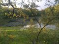
North from hashpoint.
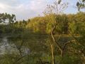
Northeast from hashpoint.
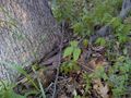
Poison ivy (geohashing hazard).

Grins.
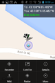
Proof screenshot.


