Difference between revisions of "2015-06-29 51 0"
From Geohashing
imported>Sourcerer m ([live] Arrived.) |
imported>Sourcerer m ([live picture] Proof. [http://www.openstreetmap.org/?lat=51.97362542&lon=.86709380&zoom=16&layers=B000FTF @51.9736,.8671]) |
||
| Line 25: | Line 25: | ||
<gallery perrow="5"> | <gallery perrow="5"> | ||
| + | |||
| + | Image:2015-06-29_51_0_Sourcerer_1435533127849.jpg | Proof. [http://www.openstreetmap.org/?lat=51.97362542&lon=.86709380&zoom=16&layers=B000FTF @51.9736,.8671] | ||
</gallery> | </gallery> | ||
Revision as of 23:14, 28 June 2015
| Mon 29 Jun 2015 in 51,0: 51.9736694, 0.8670989 geohashing.info google osm bing/os kml crox |
Location
On a public footpath, Nayland, Suffolk, UK.
Participants
Plans
Expedition two of two spanning midnight. 2015-06-28 52 1 - 2015-06-29 51 0 - ETA 00:00.
Expedition
- Arrived. -- Sourcerer (talk) @51.9736,.8671 00:12, 29 June 2015 (GMT+01:00)
Photos
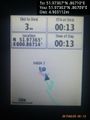
Proof. @51.9736,.8671

Achievements
Sourcerer earned the Consecutive geohash achievement
|
Sourcerer earned the Midnight Geohash achievement
|
Expeditions and Plans
| 2015-06-29 | ||
|---|---|---|
| London East, United Kingdom | Sourcerer | 1) Very close to a public footpath, Nayland, Suffolk, UK. |
| Kassel, Germany | GeorgDerReisende | The hash lies in the main street of Alfeld-Hörsum. |
| Cambridge, United Kingdom | Sourcerer | 2) On the mud flats north of Wells Next the Sea, Norfolk, UK. |
Sourcerer's Expedition Links
2015-06-28 52 1 - 2015-06-29 51 0 - LAST (until now) - KML file download of Sourcerer's expeditions for use with Google Earth.