Difference between revisions of "2015-09-26 38 -90"
imported>Kbh3rd m (→Participants) |
imported>Kbh3rd (→Photos) |
||
| Line 43: | Line 43: | ||
File:STL 38 -90 20150926-01.jpg | Proof. (Kept bouncing around) | File:STL 38 -90 20150926-01.jpg | Proof. (Kept bouncing around) | ||
File:STL 38 -90 20150926 03.jpg | Tree with a burl nearby | File:STL 38 -90 20150926 03.jpg | Tree with a burl nearby | ||
| + | File:Geohashstl-20150926-track.jpg | The straight jog southwest to the point was on foot | ||
</gallery> | </gallery> | ||
Revision as of 15:27, 28 September 2015
| Sat 26 Sep 2015 in 38,-90: 38.0737960, -90.9585734 geohashing.info google osm bing/os kml crox |
Location
In the Pea Ridge Conservation Area northwest of Potosi.
Participants
Kbh3rd and his lovely bride. (She'll follow me to the ends of the earth.)
Plans
Plans were made very late. Found ourselves hiking at Little Indian Creek CA earlier in the day and decided to go for this one just in case we hadn't picked up enough chiggers yet. The Conservation Department has an access parking lot on a short, rough gravel road very close to the meetup point.
Expedition
An easy 0.14 mile (0.23 km) walk through the woods to the meetup point. The woods were mostly tall and easy walking (except for the spider webs). More underbrush closer to the parking lot. The site is off of Highway 185 in an area that's pretty much wooded wilderness.
Follow @geohashstl on Twitter for (almost) daily notes on meetup points.
Photos
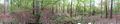
360-degree panorama at the meetup point
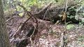
Rock ledge nearby

Proof. (Kept bouncing around)
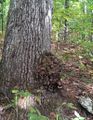
Tree with a burl nearby
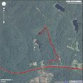
The straight jog southwest to the point was on foot


