Difference between revisions of "2015-12-29 52 0"
From Geohashing
imported>Sourcerer m (→Planning) |
imported>Sourcerer m ([live picture] Proof of arrival. [http://www.openstreetmap.org/?lat=52.75484562&lon=.26267409&zoom=16&layers=B000FTF @52.7548,.2627]) |
||
| Line 24: | Line 24: | ||
== Photos == | == Photos == | ||
<gallery> | <gallery> | ||
| + | |||
| + | Image:2015-12-29_52_0_Sourcerer_1451428375128.jpg | Proof of arrival. [http://www.openstreetmap.org/?lat=52.75484562&lon=.26267409&zoom=16&layers=B000FTF @52.7548,.2627] | ||
</gallery> | </gallery> | ||
Revision as of 22:34, 29 December 2015
| Tue 29 Dec 2015 in Cambridge, UK: 52.7548441, 0.2626942 geohashing.info google osm bing/os kml crox |
Location
In a field between the rivers Nene and Great Ouse, west of Kings Lynn, Norfolk, UK.
Participants
Plans
Expedition two of three spanning midnight - 2015-12-29 52 1 - 2015-12-29 52 0 - 2015-12-30 52 0 - ETA 22:35.
Expedition
Photos
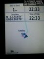
Proof of arrival. @52.7548,.2627

Achievements
Expeditions and Plans
| 2015-12-29 | ||
|---|---|---|
| Seattle, Washington | Benjamin Kaiser | In the trees/bushes (lots of ferns) behind a house in a seemingly quite wea... |
| Nürnberg, Germany | Breti | Huzza, my first Geohash Breti -- Breti (talk) @49.7548,11.2627 15:10, 29 ... |
| Bonn, Germany | Burgman | A meadow between Geistingen and Rott, near Hennef. |
| Cambridge, United Kingdom | Sourcerer | 2) In a field between the rivers Nene and Great Ouse, west of Kings Lynn, N... |
| Norwich, United Kingdom | Sourcerer | 1) In a field behind the church of St. Mary the Virgin and St. Botolph, sou... |
Sourcerer's Expedition Links
2015-12-29 52 1 - 2015-12-29 52 0 - 2015-12-30 52 0 - KML file download of Sourcerer's expeditions for use with Google Earth.