Difference between revisions of "2016-03-06 49 8"
imported>DODO (→Photos) |
imported>DODO (→Achievements) |
||
| Line 62: | Line 62: | ||
{{#vardefine:ribbonwidth|800px}} | {{#vardefine:ribbonwidth|800px}} | ||
<!-- Add any achievement ribbons you earned below, or remove this section --> | <!-- Add any achievement ribbons you earned below, or remove this section --> | ||
| + | {{land geohash | ||
| + | | latitude = 49 | ||
| + | | longitude = 8 | ||
| + | | date = 2016-03-06 | ||
| + | | name = DODO | ||
| + | }} | ||
| − | + | {{Drowned rat geohash | |
| − | + | | latitude = 49 | |
| − | + | | longitude = 8 | |
| + | | date = 2016-03-06 | ||
| + | | name = DODO | ||
| + | | reason = bull riding to the hash through wind and rain | ||
| + | }} | ||
| − | |||
| − | |||
| − | |||
| − | |||
| − | |||
| − | |||
| − | |||
| − | |||
[[Category:Expeditions]] | [[Category:Expeditions]] | ||
| − | |||
| − | |||
| − | |||
| − | |||
| − | |||
| − | |||
| − | |||
[[Category:Coordinates reached]] | [[Category:Coordinates reached]] | ||
| − | |||
| − | |||
| − | |||
| − | |||
| − | |||
| − | |||
| − | |||
| − | |||
| − | |||
| − | |||
| − | |||
| − | |||
| − | |||
| − | |||
| − | |||
| − | |||
| − | |||
| − | |||
Revision as of 20:04, 6 March 2016
| Sun 6 Mar 2016 in 49,8: 49.3370971, 8.7673922 geohashing.info google osm bing/os kml crox |
Location
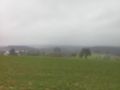
A muddy field near Gauangelloch (Fishing hole district).
Participants
Plans
No plans at all. I wanted to go for a little hike with the lady, but the weather was to bad for her. So I had a couple of time...
Expedition
I saw that the hash was in a reachable distance and decided to go there by bull. I planned the tour, packed my things and started. It was just then, that I realized that it was very windy, 3°C cold and slightly raining (but don't be afraid, the rain strengthened during expedition).
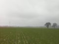
Beside of all this it was pretty easy to come close to the hash. When I reached the hash field I left the bull on an apple lawn and damned the geohashing god for putting the hash on the other side of the path. 140 m into the field, which was very muddy of course because of all the rain. There was a stand in the middle of the field near the hash and I thought if hunters are allowed to walk through the field, why should hash-hunters be not. The hash itself was at the highest point of the field on the top of a small hill, where you were fully exposed to the wind and the rain, but with a great view (or at least you would have had, if the weather would have permitted it).
I took the usual pictures (maybe you can guess the view) and quickly returned to the bike to ride home again. A three hours ride all in all with much more fun than it sounds.
Tracklog
Photos
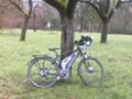
the bull at the apple tree
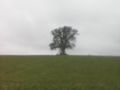
view to the hash near the tree with the stand
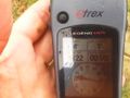
proof
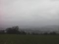
view to...
...different...
...directions
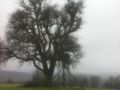
the tree with the stand seen fron the hash
another proof

wet hasher


Achievements
DODO earned the Land geohash achievement
|
DODO earned the Drowned Rat Geohash Achievement
|