Difference between revisions of "2016-04-06 52 9"
From Geohashing
imported>GeorgDerReisende (new report) |
imported>GeorgDerReisende (expedition report for Harsum) |
||
| Line 1: | Line 1: | ||
| − | |||
| − | |||
| − | |||
| − | |||
| − | |||
| − | |||
| − | |||
| − | |||
| − | |||
| − | |||
{{meetup graticule | {{meetup graticule | ||
| lat=52 | | lat=52 | ||
| Line 19: | Line 9: | ||
== Location == | == Location == | ||
| − | + | ||
| + | The hash lay at the junction of Haseder Weg and Tannenkamp in Harsum. | ||
== Participants == | == Participants == | ||
| − | + | ||
| − | + | [[User:GeorgDerReisende|GeorgDerReisende]] | |
== Plans == | == Plans == | ||
| − | + | ||
| + | Hitchhiking and walking. | ||
== Expedition == | == Expedition == | ||
| − | |||
| − | + | I left home at 10:30, started to hitchhike at 11:00, after one hour waiting a car stopped and I got a lift to the service station Göttingen. There I had to wait another 90 minutes and I got a lift to the motorway junction Hildesheim-Drispenstedt, where I arrived at 14:45. Then I walked to the hash, where I arrived at 15:55. I took the usual photos and tried a hash o'clock-shot, but at 16:00 the hash was at all places about six meters away. | |
| − | |||
== Photos == | == Photos == | ||
| − | |||
| − | |||
| − | |||
<gallery perrow="5"> | <gallery perrow="5"> | ||
| + | Image:2016-04-06 52 9 GeorgDerReisende 0019.jpg | first view to Harsum | ||
| + | Image:2016-04-06 52 9 GeorgDerReisende 0036.jpg | proof of arrival | ||
| + | Image:2016-04-06 52 9 GeorgDerReisende 0037.jpg | east | ||
| + | Image:2016-04-06 52 9 GeorgDerReisende 0038.jpg | north | ||
| + | Image:2016-04-06 52 9 GeorgDerReisende 0039.jpg | west | ||
| + | Image:2016-04-06 52 9 GeorgDerReisende 0040.jpg | south | ||
| + | Image:2016-04-06 52 9 GeorgDerReisende 0041.jpg | me | ||
| + | Image:2016-04-06 52 9 GeorgDerReisende 0042.jpg | the tree at NNW looked at me | ||
</gallery> | </gallery> | ||
| Line 45: | Line 40: | ||
<!-- Add any achievement ribbons you earned below, or remove this section --> | <!-- Add any achievement ribbons you earned below, or remove this section --> | ||
| − | + | {{Thumbs Up | latitude = 52 | longitude = 9 | date = 2016-04-06 | name = GeorgDerReisende }} | |
| − | |||
| − | |||
| − | + | [[Category:Expeditions]] | |
| − | |||
| − | [[Category: | ||
| − | |||
| − | + | [[Category:Expeditions with photos]] | |
| − | |||
| − | |||
| − | |||
| − | |||
| − | |||
| − | |||
| − | |||
| − | |||
| − | |||
[[Category:Coordinates reached]] | [[Category:Coordinates reached]] | ||
| − | |||
| − | |||
| − | |||
| − | |||
| − | |||
| − | |||
| − | |||
| − | |||
| − | |||
| − | |||
| − | |||
| − | |||
| − | |||
| − | |||
| − | |||
| − | |||
| − | |||
| − | |||
Revision as of 21:59, 6 April 2016
| Wed 6 Apr 2016 in 52,9: 52.2058044, 9.9566613 geohashing.info google osm bing/os kml crox |
Location
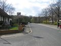
The hash lay at the junction of Haseder Weg and Tannenkamp in Harsum.
Participants
Plans
Hitchhiking and walking.
Expedition
I left home at 10:30, started to hitchhike at 11:00, after one hour waiting a car stopped and I got a lift to the service station Göttingen. There I had to wait another 90 minutes and I got a lift to the motorway junction Hildesheim-Drispenstedt, where I arrived at 14:45. Then I walked to the hash, where I arrived at 15:55. I took the usual photos and tried a hash o'clock-shot, but at 16:00 the hash was at all places about six meters away.
Photos
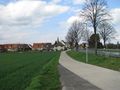
first view to Harsum
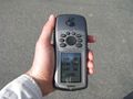
proof of arrival
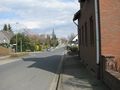
east
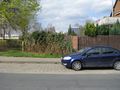
north
west
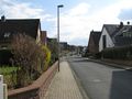
south

me
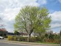
the tree at NNW looked at me


Achievements
GeorgDerReisende earned the Thumbs Up Geohash Achievement
|