Difference between revisions of "2016-04-14 61 24"
imported>Tilley |
imported>FippeBot m (Location) |
||
| Line 47: | Line 47: | ||
[[Category:Expeditions with photos]] | [[Category:Expeditions with photos]] | ||
[[Category:Coordinates reached]] | [[Category:Coordinates reached]] | ||
| + | {{location|FI|06}} | ||
Latest revision as of 00:13, 16 August 2019
| Thu 14 Apr 2016 in 61,24: 61.1642903, 24.4681409 geohashing.info google osm bing/os kml crox |
Location
Near the peninsula Muttamonkärki of lake Hauhonselkä. The point lies in the forest quite near the road. There is some building nearby.
Participants
Plans
I will attempt to reach this point today on my way home, around 17. Will leave a crox-poster at the site, and write the report in the evening.
Expedition
It was a sunny and beautiful spring day. It still felt quite chilly, because there was very strong and cold wind coming straight from the North. I had unusually came all the way from home to work by car yesterday, and today was the time to go back. Conveniently there was a hashpoint only a couple of kilometers stray from my route, so of course I would try it, it was a nice break from the monotonous motor- and highway driving.
I turned from Hämeenlinna towards Pälkäne and reseted my part-distance gauge. I had beforehand looked up from Google Maps that I had to drive 16 km towards Pälkäne and then turn into smaller roads. First I tried to find the way in the maze of small and even smaller gravel roads with a coarse map I had printed out, but soon I encountered some booms and I had to resort to the smartphone to find the right way. With the phone, I navigated without further problems to the hash-site.
The final road turned towards the lake and for a moment there was a nice view because the forest on the top of the hill and beside the road had been cut clear last winter. On the other side of the road there were some cottages next to each other. The road descended towards the shore and into a forest again. The hashpoint was right after the line of cottages.
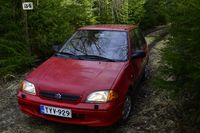
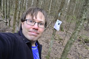
I parked my car on the intersection to the final cottage and quickly scrambled to the forest with camera and GPS device. The point was only about 50 meters into the mixed forest, which was quite easy to walk in, because there weren't much undergrowth. I found the hashpoint, posted the poster to a nearby tree and took a couple of pictures.
Then I returned to the car and resumed my journey home. A nice break!
Additional photos
Achievements
Tilley earned the Land geohash achievement
|


