Difference between revisions of "2016-04-23 38 -77"
From Geohashing
imported>Mckaysalisbury (Actually fixing the link) |
imported>Mckaysalisbury (→Achievements) |
||
| Line 50: | Line 50: | ||
{{land geohash | latitude = 38 | longitude = -77 | date = 2016-04-23 | name = Peter and McKay }} | {{land geohash | latitude = 38 | longitude = -77 | date = 2016-04-23 | name = Peter and McKay }} | ||
{{mnimb geohash | latitude = 38 | longitude = -77 | date = 2016-04-23 | name = Peter }} | {{mnimb geohash | latitude = 38 | longitude = -77 | date = 2016-04-23 | name = Peter }} | ||
| + | {{Bicycle geohash | latitude = 38 | longitude = -77 | date = 2016-04-23 | name = Peter }} | ||
{{consecutive geohash | count = 2 | latitude = 38 | longitude = -77 | date = 2016-04-23 | name = McKay }} | {{consecutive geohash | count = 2 | latitude = 38 | longitude = -77 | date = 2016-04-23 | name = McKay }} | ||
{{Meet-up | latitude = 38 | longitude = -77 | date = 2016-04-23 | name = Peter and McKay}} | {{Meet-up | latitude = 38 | longitude = -77 | date = 2016-04-23 | name = Peter and McKay}} | ||
Revision as of 22:50, 23 April 2016
| Sat 23 Apr 2016 in 38,-77: 38.9312837, -77.1141124 geohashing.info google osm bing/os kml crox |
Location
In the Chesapeake & Ohio Canal National Park, about 75 meters off the canal towpath.
Participants
- Peter Kaminski
- McKay (talk) (and family)
Plans
The plan was to meet at the spot at 4:00 pm. (see the talk page)
Peter planned on biking along the canal towpath from Rosslyn.
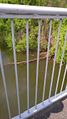
McKay planned on driving, parking at the parking lot across the canal, and walking across the Chain Bridge
Expedition
Tracklog
Photos
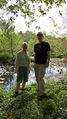
Peter and McKay
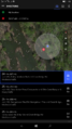
GPS Proof
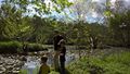
McKay and Sons
Two turtles on a log nearby


Achievements
Peter and McKay earned the Land geohash achievement
|
Peter earned the Bicycle geohash achievement
|
McKay earned the Consecutive geohash achievement
|
Peter and McKay earned the Meet-up achievement
|