Difference between revisions of "2016-05-30 39 -76"
imported>Djaquay ([live picture]The trail to the hashpoint.) |
imported>Djaquay |
||
| Line 19: | Line 19: | ||
== Location == | == Location == | ||
| − | + | In Elvaton Park, south of Glen Burnie (outskirts of Baltimore, MD). | |
== Participants == | == Participants == | ||
| − | + | [[User:Djaquay|Djaquay]] ([[User talk:Djaquay|talk]]), wife, and daughter. | |
| − | |||
== Plans == | == Plans == | ||
| − | |||
== Expedition == | == Expedition == | ||
| − | + | We started out aiming to head for the hashpoint, then go get something to eat down in Annapolis. But as the hashpoint was 80mi/125km away, direct, by the time we got down there, everybody (else) was getting hungry, so we hit Annapolis first. Ate at the apparently world famous (or at least "as seen on TV") Chick 'n Ruth's Delly (sic); had a couple of beers and a delicious omelet, took a tour of town, walked around a bit, and grabbed some ice cream. | |
| − | + | And then headed for the hashpoint. Park was pretty well deserted by the time we got there, a little after 6pm. Rain, which had been forcasted, held off until after we left, but it was starting to look gloomy. Fortunately, the point was conveniently just off a path, at the edge of a patch of light woods, maybe 100m from the parking lot. | |
| − | |||
== Photos == | == Photos == | ||
| − | |||
| − | |||
| − | |||
<gallery perrow="5"> | <gallery perrow="5"> | ||
| − | |||
| − | |||
Image:2016-05-30_39_-76_djaquay_1464655358515.jpg|The beer, at the diner. | Image:2016-05-30_39_-76_djaquay_1464655358515.jpg|The beer, at the diner. | ||
| − | |||
Image:2016-05-30_39_-76_djaquay_1464655424663.jpg|The trail to the hashpoint. | Image:2016-05-30_39_-76_djaquay_1464655424663.jpg|The trail to the hashpoint. | ||
| + | Image:2016-05-30_39_-76_djaquay_1464655161921.jpg|The proof. | ||
</gallery> | </gallery> | ||
| Line 50: | Line 42: | ||
{{#vardefine:ribbonwidth|800px}} | {{#vardefine:ribbonwidth|800px}} | ||
<!-- Add any achievement ribbons you earned below, or remove this section --> | <!-- Add any achievement ribbons you earned below, or remove this section --> | ||
| + | |||
| + | [[Category:Expeditions]] | ||
| + | [[Category:Expeditions with photos]] | ||
| + | [[Category:Coordinates reached]] | ||
<!-- =============== USEFUL CATEGORIES FOLLOW ================ | <!-- =============== USEFUL CATEGORIES FOLLOW ================ | ||
| Line 63: | Line 59: | ||
<!-- An actual expedition: | <!-- An actual expedition: | ||
| − | |||
-- and one or more of -- | -- and one or more of -- | ||
| − | |||
[[Category:Expeditions with videos]] | [[Category:Expeditions with videos]] | ||
[[Category:Expedition without GPS]] | [[Category:Expedition without GPS]] | ||
| Line 71: | Line 65: | ||
<!-- if you reached your coords: | <!-- if you reached your coords: | ||
| − | |||
Revision as of 00:55, 31 May 2016
| Mon 30 May 2016 in 39,-76: 39.1077141, -76.5989759 geohashing.info google osm bing/os kml crox |
Location
In Elvaton Park, south of Glen Burnie (outskirts of Baltimore, MD).
Participants
Djaquay (talk), wife, and daughter.
Plans
Expedition
We started out aiming to head for the hashpoint, then go get something to eat down in Annapolis. But as the hashpoint was 80mi/125km away, direct, by the time we got down there, everybody (else) was getting hungry, so we hit Annapolis first. Ate at the apparently world famous (or at least "as seen on TV") Chick 'n Ruth's Delly (sic); had a couple of beers and a delicious omelet, took a tour of town, walked around a bit, and grabbed some ice cream.
And then headed for the hashpoint. Park was pretty well deserted by the time we got there, a little after 6pm. Rain, which had been forcasted, held off until after we left, but it was starting to look gloomy. Fortunately, the point was conveniently just off a path, at the edge of a patch of light woods, maybe 100m from the parking lot.
Photos
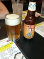
The beer, at the diner.
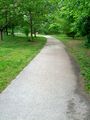
The trail to the hashpoint.
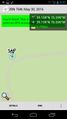
The proof.


Achievements