Difference between revisions of "2008-05-31 37 -121"
From Geohashing
imported>ErWenn |
imported>ReletBot m (Failed => Not reached) |
||
| Line 32: | Line 32: | ||
[[Category:Expeditions with photos]] | [[Category:Expeditions with photos]] | ||
[[Category:Coordinates not reached]] | [[Category:Coordinates not reached]] | ||
| − | [[Category: | + | [[Category:Not reached - No public access]] |
[[Category:Expeditions with dogs]] | [[Category:Expeditions with dogs]] | ||
Revision as of 20:27, 31 March 2009
| Sat 31 May 2008 in San Jose, California: 37.0374871, -121.2812665 geohashing.info google osm bing/os kml crox |
Planning information
- Google Maps link (37.0374870832648,-121.281266476764)
- Appears to be about a mile off Hwy 152, up an existing fire road, at the crest of a hill or ridge.
- Tapin will try to be there; if it turns out it's marked as private, perhaps the Bell Station Cafe (sorry, best link I could find) -- about two miles west on 152 -- would work as an alternate location?
- Ted will try to be there, with Vicki and games. Concur about Bell Station, but we'll likely hang out at the nearest fence-location until about 4:20, to catch stragglers.
- Inaccessible from highway, posted no trespassing signs. Sadly, the Bell Station Cafe is closed and locked. Try again next week. --Tapin 23:33, 31 May 2008 (UTC)
Evolution
- Ted and Vicki tried to get there, but the actual spot was beyond private/locked gates, at least from the 3 spots we tried off of 152. Also, the Bell Station Cafe is closed.
- Photo Gallery for 2008-05-31 37 -121
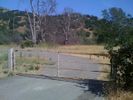
A shot at the 1st gate we tried

One of Vicki and the dogs at our closest point to the location
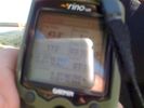
A blurry & reflective shot of the GPS at our closest point.
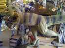
On the way home, we stopped at an archery shop in nearby Gilroy with a 3D practice target of a Velociraptor, which seemed somehow appropriate.
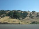
The dirt road to the geohash point is visible to the right of this picture; unfortunately, it's completely inaccessible to the public.
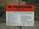
Not wanting to be mistaken for a hunter and referred to the Sheriff's Department, I took this picture and skedaddled.


