Difference between revisions of "2016-07-20 52 1"
From Geohashing
imported>Sourcerer (→Planning) |
imported>Sourcerer m ([live picture] Arrived. [http://www.openstreetmap.org/?lat=52.89754987&lon=1.11368001&zoom=16&layers=B000FTF @52.8975,1.1137]) |
||
| Line 26: | Line 26: | ||
<gallery caption="Photo Gallery" widths="200px" heights="200px" perrow="3"> | <gallery caption="Photo Gallery" widths="200px" heights="200px" perrow="3"> | ||
| + | |||
| + | Image:2016-07-20_52_1_Sourcerer_1469046984329.jpg | Arrived. [http://www.openstreetmap.org/?lat=52.89754987&lon=1.11368001&zoom=16&layers=B000FTF @52.8975,1.1137] | ||
</gallery> | </gallery> | ||
Revision as of 20:38, 20 July 2016
| Wed 20 Jul 2016 in Norwich, UK: 52.8975584, 1.1136620 geohashing.info google osm bing/os kml crox |
Location
A field perimeter point between Holt and Hempstead, Norfolk, UK.
Participants
Plans
One of two spanning midnight - 2016-07-20 52 1 - 2016-07-21 52 1 - ETA 21:55.
Expedition
Photos
- Photo Gallery
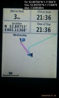
Arrived. @52.8975,1.1137

Achievements
Expeditions and Plans
| 2016-07-20 | ||
|---|---|---|
| Norwich, United Kingdom | Sourcerer | A field perimeter point between Holt and Hempstead, Norfolk, UK. |
Sourcerer's Expedition Links
2016-07-18 52 1 - 2016-07-20 52 1 - 2016-07-21 52 1 - KML file download of Sourcerer's expeditions for use with Google Earth.