Difference between revisions of "2017-01-25 48 11"
imported>Claralucia9 (→Photos) |
imported>Solli |
||
| Line 1: | Line 1: | ||
| − | |||
| − | |||
| − | |||
| − | |||
| − | |||
| − | |||
| − | |||
| − | |||
| − | |||
| − | |||
{{meetup graticule | {{meetup graticule | ||
| lat=48 | | lat=48 | ||
| Line 19: | Line 9: | ||
== Location == | == Location == | ||
| − | On a field near Höhenkirchen-Siegertsbrunn | + | On a snow-covered field near Höhenkirchen-Siegertsbrunn |
== Participants == | == Participants == | ||
<!-- who attended: If you link to your wiki user name in this section, your expedition will be picked up by the various statistics generated for geohashing. You may use three tildes ~ as a shortcut to automatically insert the user signature of the account you are editing with. | <!-- who attended: If you link to your wiki user name in this section, your expedition will be picked up by the various statistics generated for geohashing. You may use three tildes ~ as a shortcut to automatically insert the user signature of the account you are editing with. | ||
--> | --> | ||
| − | claralucia9 | + | * claralucia9 |
| + | * [[User:Solli|Solli]] | ||
== Plans == | == Plans == | ||
| Line 35: | Line 26: | ||
On my way back I tried to log a geocache, but were unlucky this time.... | On my way back I tried to log a geocache, but were unlucky this time.... | ||
| − | + | Solli: | |
| − | + | Since I had an appointment in Haar (less than 15km away) that evening the hashpoint was more or less on my way. I went there after work and left the car some 300m away. I then walked along the track south of the hashpoint and crossed the last few meters across the field. Near the location I already discovered some footprints, appearantly claralucia9's. The spot itself was easy to find because it was marked with an X. I reached it at 17:37. What a pity I've missed claralucia9, but I couldn't have made it any earlier. | |
| + | |||
== Photos == | == Photos == | ||
| Line 42: | Line 34: | ||
Image:2012-##-## ## ## Alpha.jpg | Witty Comment | Image:2012-##-## ## ## Alpha.jpg | Witty Comment | ||
--> | --> | ||
| + | claralucia9: | ||
<gallery perrow="5"> | <gallery perrow="5"> | ||
| − | |||
Image:2017-01-25_16.14.04.png|at the hash coordinates - logproof | Image:2017-01-25_16.14.04.png|at the hash coordinates - logproof | ||
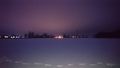
Image:2017-01-25_17.09.49.jpg|the field @ the hash coordinates | Image:2017-01-25_17.09.49.jpg|the field @ the hash coordinates | ||
Image:2017-01-25_48_11_Claralucia9_1485365290891.jpg|In the middle of a snow field | Image:2017-01-25_48_11_Claralucia9_1485365290891.jpg|In the middle of a snow field | ||
| + | </gallery> | ||
| + | |||
| + | Solli: | ||
| + | <gallery perrow="5"> | ||
| + | Image:2017-01-25_48_11_Solli-01.png|Proof | ||
| + | Image:2017-01-25_48_11_Solli-02.JPG|X marks the spot | ||
| + | Image:2017-01-25_48_11_Solli-03.JPG|View from the hashpoint | ||
| + | Image:2017-01-25_48_11_Solli-04.JPG|Proof of temperature | ||
</gallery> | </gallery> | ||
== Achievements == | == Achievements == | ||
{{#vardefine:ribbonwidth|800px}} | {{#vardefine:ribbonwidth|800px}} | ||
| − | + | {{land geohash | |
| + | | latitude = 48 | ||
| + | | longitude = 11 | ||
| + | | date = 2017-01-25 | ||
| + | | name = claralucia9 and Solli | ||
| + | }} | ||
| + | |||
| + | {{Frozen Geohash | ||
| + | | latitude = 48 | ||
| + | | longitude = 11 | ||
| + | | date = 2017-01-25 | ||
| + | | temperature = -5°C | ||
| + | | name = claralucia9 and Solli | ||
| + | | image = 2017-01-25_48_11_Solli-04.JPG | ||
| + | }} | ||
<!-- =============== USEFUL CATEGORIES FOLLOW ================ | <!-- =============== USEFUL CATEGORIES FOLLOW ================ | ||
| − | |||
| − | |||
| − | |||
| − | |||
| − | |||
| − | |||
| − | |||
| − | |||
| − | |||
| − | |||
| − | |||
| − | |||
| − | |||
[[Category:Expeditions]] | [[Category:Expeditions]] | ||
| − | |||
[[Category:Expeditions with photos]] | [[Category:Expeditions with photos]] | ||
| − | |||
| − | |||
| − | |||
| − | |||
| − | |||
[[Category:Coordinates reached]] | [[Category:Coordinates reached]] | ||
| − | |||
| − | |||
| − | |||
| − | |||
| − | |||
| − | |||
| − | |||
| − | |||
| − | |||
| − | |||
| − | |||
| − | |||
| − | |||
| − | |||
| − | |||
| − | |||
| − | |||
| − | |||
Revision as of 09:13, 26 January 2017
| Wed 25 Jan 2017 in 48,11: 48.0235137, 11.6983487 geohashing.info google osm bing/os kml crox |
Location
On a snow-covered field near Höhenkirchen-Siegertsbrunn
Participants
- claralucia9
- Solli
Plans
Solli plans to go there around 5:30 p.m.
Expedition
claralucia9: What a coincidence: I've been looking at the hash coordinates for over a month now and they've been too far away all the time, but suddenly I get two close by in one week! Hence I had to get in the car this evening and drive over to Höhenkirchen. Parked my car at the road side and started to walk along a bicycle track a bit. Then I had to walk straight into a field. Luckily it's winter time and no crops got damaged. Leaving my footprints in the snow I made it to the coordinates. No other footprints around so I guess I may have been the only one here today. Took my pictures and then back to the warmth of the car. On my way back I tried to log a geocache, but were unlucky this time....
Solli: Since I had an appointment in Haar (less than 15km away) that evening the hashpoint was more or less on my way. I went there after work and left the car some 300m away. I then walked along the track south of the hashpoint and crossed the last few meters across the field. Near the location I already discovered some footprints, appearantly claralucia9's. The spot itself was easy to find because it was marked with an X. I reached it at 17:37. What a pity I've missed claralucia9, but I couldn't have made it any earlier.
Photos
claralucia9:
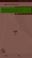
at the hash coordinates - logproof
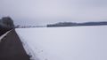
the field @ the hash coordinates

In the middle of a snow field


Solli:
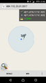
Proof
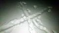
X marks the spot
View from the hashpoint
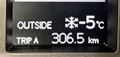
Proof of temperature


Achievements
claralucia9 and Solli earned the Land geohash achievement
|
claralucia9 and Solli earned the Frozen Geohash Achievement
|