Difference between revisions of "2017-01-29 48 8"
imported>DODO (Created page with "{{subst:Expedition |lat = 48 |lon = 8 |date = 2017-01-29 }}") |
imported>DODO |
||
| Line 20: | Line 20: | ||
== Location == | == Location == | ||
<!-- where you've surveyed the hash to be --> | <!-- where you've surveyed the hash to be --> | ||
| + | A lawn near Ölbrunn. | ||
== Participants == | == Participants == | ||
<!-- who attended: If you link to your wiki user name in this section, your expedition will be picked up by the various statistics generated for geohashing. You may use three tildes ~ as a shortcut to automatically insert the user signature of the account you are editing with. | <!-- who attended: If you link to your wiki user name in this section, your expedition will be picked up by the various statistics generated for geohashing. You may use three tildes ~ as a shortcut to automatically insert the user signature of the account you are editing with. | ||
--> | --> | ||
| + | [[User:DODO|DODO]] | ||
== Plans == | == Plans == | ||
<!-- what were the original plans --> | <!-- what were the original plans --> | ||
| + | I had some time today, the weather was fine (not to cold, no rainfall or snow, and even some sun). So I decided to go on an adventure. This was the one closest to my home. I wanted to go there by bull and ride home by train. | ||
== Expedition == | == Expedition == | ||
<!-- how it all turned out. your narrative goes here. --> | <!-- how it all turned out. your narrative goes here. --> | ||
| + | I started at ten past ten and it was quite cold at that time in Speyer. I've been on that tour for several times and so there wasn't to much to tell. The ride through the Rhine valley is very plain. In Bruchsal, after 30 kilometers I reached the Kraichgau, and the profile gets a little more exciting. But the road follows the rails and these follow a river, so there were still hardly any hills. After 53 kilometers I reached the station in Kleinvillars. I knew, I had to return here. But first, I must visit the chosen point. Some minutes later I reached Ölbrunn and was surprised how beautiful this little town was. So many old timbered houses around a large oval place made a great impression. One kilometer later I was at the hash. It was an easy accessible lawn. I just walked there, took some pictures and returned to my bull. Then I followed the same way back to the station in Kleinvillars. From here it took me 1 1/2 hours to return. I reached hoe at 14:30 again. | ||
== Tracklog == | == Tracklog == | ||
<!-- if your GPS device keeps a log, you may post a link here --> | <!-- if your GPS device keeps a log, you may post a link here --> | ||
| − | + | [https://www.komoot.de/tour/14108163 60 KM by bull] and [https://www.komoot.de/tour/14111845 64 KM back by train] | |
== Photos == | == Photos == | ||
<!-- Insert pictures between the gallery tags using the following format: | <!-- Insert pictures between the gallery tags using the following format: | ||
Image:2012-##-## ## ## Alpha.jpg | Witty Comment | Image:2012-##-## ## ## Alpha.jpg | Witty Comment | ||
--> | --> | ||
| − | <gallery perrow=" | + | <gallery perrow="4"> |
| + | Image:2017-01-29_48_8-2.jpg|view from where I parked my bull | ||
| + | Image:2017-01-29_48_8-3.jpg|bull | ||
| + | Image:2017-01-29_48_8-1.png|proof | ||
| + | Image:2017-01-29_48_8-4.jpg|view from the hash to the east | ||
| + | Image:2017-01-29_48_8-5.jpg|the west | ||
| + | Image:2017-01-29_48_8-6.jpg|noth | ||
| + | Image:2017-01-29_48_8-7.jpg|hasher | ||
| + | Image:2017-01-29_48_8-8.jpg|south-east (still snow!) | ||
</gallery> | </gallery> | ||
== Achievements == | == Achievements == | ||
{{#vardefine:ribbonwidth|800px}} | {{#vardefine:ribbonwidth|800px}} | ||
| − | + | {{land geohash | |
| − | + | | latitude = 48 | |
| − | + | | longitude = 8 | |
| − | + | | date = 2017-01-29 | |
| − | + | | name = [[User:DODO|DODO]] | |
| − | + | }} | |
| − | |||
| − | |||
| − | |||
| − | |||
| − | [[ | ||
| − | |||
| − | |||
| − | |||
| − | |||
| − | |||
[[Category:Expeditions]] | [[Category:Expeditions]] | ||
| − | |||
| − | |||
| − | |||
| − | |||
| − | |||
| − | |||
| − | |||
[[Category:Coordinates reached]] | [[Category:Coordinates reached]] | ||
| − | |||
| − | |||
| − | |||
| − | |||
| − | |||
| − | |||
| − | |||
| − | |||
| − | |||
| − | |||
| − | |||
| − | |||
| − | |||
| − | |||
| − | |||
| − | |||
| − | |||
| − | |||
Revision as of 14:08, 29 January 2017
| Sun 29 Jan 2017 in 48,8: 48.9710690, 8.7476478 geohashing.info google osm bing/os kml crox |
Location
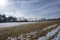
A lawn near Ölbrunn.
Participants
Plans
I had some time today, the weather was fine (not to cold, no rainfall or snow, and even some sun). So I decided to go on an adventure. This was the one closest to my home. I wanted to go there by bull and ride home by train.
Expedition
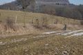
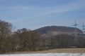
I started at ten past ten and it was quite cold at that time in Speyer. I've been on that tour for several times and so there wasn't to much to tell. The ride through the Rhine valley is very plain. In Bruchsal, after 30 kilometers I reached the Kraichgau, and the profile gets a little more exciting. But the road follows the rails and these follow a river, so there were still hardly any hills. After 53 kilometers I reached the station in Kleinvillars. I knew, I had to return here. But first, I must visit the chosen point. Some minutes later I reached Ölbrunn and was surprised how beautiful this little town was. So many old timbered houses around a large oval place made a great impression. One kilometer later I was at the hash. It was an easy accessible lawn. I just walked there, took some pictures and returned to my bull. Then I followed the same way back to the station in Kleinvillars. From here it took me 1 1/2 hours to return. I reached hoe at 14:30 again.
Tracklog
60 KM by bull and 64 KM back by train
Photos
view from where I parked my bull
bull
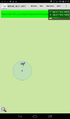
proof
view from the hash to the east
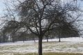
the west
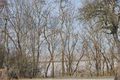
noth
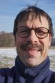
hasher
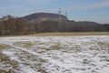
south-east (still snow!)


Achievements
DODO earned the Land geohash achievement
|