Difference between revisions of "2017-02-18 49 8"
imported>Rincewind (→Expedition) |
imported>Rincewind (→Achievements) |
||
| Line 53: | Line 53: | ||
{{#vardefine:ribbonwidth|800px}} | {{#vardefine:ribbonwidth|800px}} | ||
<!-- Add any achievement ribbons you earned below, or remove this section --> | <!-- Add any achievement ribbons you earned below, or remove this section --> | ||
| + | "Land" and "Easy" would apply, if I weren't too lazy. :) | ||
<!-- =============== USEFUL CATEGORIES FOLLOW ================ | <!-- =============== USEFUL CATEGORIES FOLLOW ================ | ||
Delete the next line ONLY if you have chosen the appropriate categories below. If you are unsure, don't worry. People will read your report and help you with the classification. --> | Delete the next line ONLY if you have chosen the appropriate categories below. If you are unsure, don't worry. People will read your report and help you with the classification. --> | ||
[[Category:New report]] | [[Category:New report]] | ||
| − | + | [[Category:Expeditions]] | |
| − | |||
| − | |||
| − | |||
| − | |||
| − | |||
| − | |||
| − | |||
| − | |||
| − | |||
| − | |||
| − | [[Category:Expeditions]] | ||
| − | |||
[[Category:Expeditions with photos]] | [[Category:Expeditions with photos]] | ||
| − | |||
| − | |||
| − | |||
| − | |||
| − | |||
[[Category:Coordinates reached]] | [[Category:Coordinates reached]] | ||
| − | |||
| − | |||
| − | |||
| − | |||
| − | |||
| − | |||
| − | |||
| − | |||
| − | |||
| − | |||
| − | |||
| − | |||
| − | |||
| − | |||
| − | |||
| − | |||
| − | |||
| − | |||
Revision as of 19:03, 18 February 2017
| Sat 18 Feb 2017 in 49,8: 49.7858425, 8.6326259 geohashing.info google osm bing/os kml crox |
Location
A mere 2.8km as the bird flies (and 5km as the car drives...) next to federal road B3. Can't not go. :)
Participants
Plans
Expedition
When Yakamoz came home, we left for the expedition. A couple minutes of driving later, we found that we were lucky- Rincewind had misjudged the coordinates to be to the right side of the road, which would have been military area and fenced off.
It was to the left, though and we just had to park the car on the side of the road bank and walk less than a hundred meters. After fighting through a bit of thorns, we could walk straight to the coordinates in the woods. The GPS gadget easily counted down the distance and we didn't even have to do a hash dance. Unfortunately, Rincewind forgot the camera (spell: mobile phone) in the car and so we don't have a hashsite photo- just imagine a fairly standard Pine forest. All in all, a very easy hash and door to door less than thirty minutes, I guess. :)
Tracklog
Photos
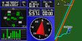
GPS doodad screenshot

Stupid grin(TM)
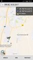
Distance from parking spot


Achievements
"Land" and "Easy" would apply, if I weren't too lazy. :)