Difference between revisions of "2017-05-13 49 6"
imported>FelixTheCat (Created page with "{{subst:Expedition |lat = 49 |lon = 6 |date = 2017-05-13 }}") |
imported>FelixTheCat |
||
| Line 1: | Line 1: | ||
| − | |||
| − | |||
| − | |||
| − | |||
| − | |||
| − | |||
| − | |||
| − | |||
| − | |||
| − | |||
{{meetup graticule | {{meetup graticule | ||
| lat=49 | | lat=49 | ||
| Line 14: | Line 4: | ||
| date=2017-05-13 | | date=2017-05-13 | ||
}} | }} | ||
| − | |||
| − | |||
__NOTOC__ | __NOTOC__ | ||
| − | |||
== Location == | == Location == | ||
| − | + | On a hill just outside Serrig, state of Rhineland-Palatinate, Germany. | |
== Participants == | == Participants == | ||
| − | + | [[User:FelixTheCat|FelixTheCat]] ([[User talk:FelixTheCat|talk]]) | |
| − | |||
| − | |||
| − | |||
| − | |||
== Expedition == | == Expedition == | ||
| − | + | I was on a sightseeing trip in the Trier area, and this hash looked interesting: situated right next to a roadside car park named "Schöne Aussicht", which means "Beautiful view". So I parked the hashmobile and had a look at this view. It was beautiful indeed: it was on a hilltop overlooking a meander in the river Saar, with green fields in the front and rolling hills on the horizon. It was somewhat busy with people preparing hang gliders and several already airborne. After admiring the view I walked a few hundred metres into the forest and found the hash. Made an XKCD marked out of loose branches and then went back on the road. | |
| − | |||
| − | |||
| − | |||
== Photos == | == Photos == | ||
| − | |||
| − | |||
| − | |||
<gallery perrow="5"> | <gallery perrow="5"> | ||
| + | Image:2017-05-13 49 6 FelixTheCat 1.JPG | Entering the village of Serrig. | ||
| + | Image:2017-05-13 49 6 FelixTheCat 2.JPG | A map at the car park, showing that this place is called "Schöne Aussicht". | ||
| + | Image:2017-05-13 49 6 FelixTheCat 3.JPG | Someone getting ready to soar. | ||
| + | Image:2017-05-13 49 6 FelixTheCat 4.JPG | It is a beautiful view indeed. | ||
| + | Image:2017-05-13 49 6 FelixTheCat 5.JPG | The forest, a few hundred metres to the northwest. | ||
| + | Image:2017-05-13 49 6 FelixTheCat 6.JPG | This weird hole was right next to the hash. At first I suspected another hasher who wanted to leave an unmissable marker, but it turned out to be a drainage hole of some sort. | ||
| + | Image:2017-05-13 49 6 FelixTheCat 7.JPG | My XKCD marker, and Lloyd celebrating another successful expedition. | ||
| + | Image:2017-05-13 49 6 FelixTheCat 8.png | GPS proof. An actual zero reading, even in a forest. | ||
| + | Image:2017-05-13 49 6 FelixTheCat 9.JPG | Back at the car park, with a sky full of hang gliders. | ||
</gallery> | </gallery> | ||
| − | |||
| − | |||
| − | |||
| − | |||
| − | |||
| − | |||
| − | |||
| − | |||
| − | |||
| − | |||
| − | |||
| − | |||
| − | |||
| − | |||
| − | |||
| − | |||
| − | |||
| − | |||
[[Category:Expeditions]] | [[Category:Expeditions]] | ||
| − | |||
[[Category:Expeditions with photos]] | [[Category:Expeditions with photos]] | ||
| − | |||
| − | |||
| − | |||
| − | |||
| − | |||
[[Category:Coordinates reached]] | [[Category:Coordinates reached]] | ||
| − | |||
| − | |||
| − | |||
| − | |||
| − | |||
| − | |||
| − | |||
| − | |||
| − | |||
| − | |||
| − | |||
| − | |||
| − | |||
| − | |||
| − | |||
| − | |||
| − | |||
| − | |||
Revision as of 08:20, 14 May 2017
| Sat 13 May 2017 in 49,6: 49.5715669, 6.6126325 geohashing.info google osm bing/os kml crox |
Location
On a hill just outside Serrig, state of Rhineland-Palatinate, Germany.
Participants
Expedition
I was on a sightseeing trip in the Trier area, and this hash looked interesting: situated right next to a roadside car park named "Schöne Aussicht", which means "Beautiful view". So I parked the hashmobile and had a look at this view. It was beautiful indeed: it was on a hilltop overlooking a meander in the river Saar, with green fields in the front and rolling hills on the horizon. It was somewhat busy with people preparing hang gliders and several already airborne. After admiring the view I walked a few hundred metres into the forest and found the hash. Made an XKCD marked out of loose branches and then went back on the road.
Photos
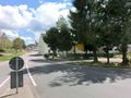
Entering the village of Serrig.
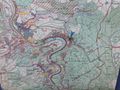
A map at the car park, showing that this place is called "Schöne Aussicht".
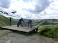
Someone getting ready to soar.
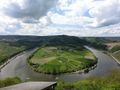
It is a beautiful view indeed.
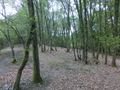
The forest, a few hundred metres to the northwest.
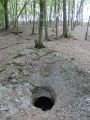
This weird hole was right next to the hash. At first I suspected another hasher who wanted to leave an unmissable marker, but it turned out to be a drainage hole of some sort.
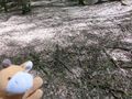
My XKCD marker, and Lloyd celebrating another successful expedition.
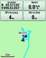
GPS proof. An actual zero reading, even in a forest.
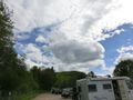
Back at the car park, with a sky full of hang gliders.


