Difference between revisions of "2017-07-22 43 -76"
imported>Pedalpusher (new expedition report) |
imported>Pedalpusher (added pictures) |
||
| Line 8: | Line 8: | ||
== Expedition == | == Expedition == | ||
| − | As mentioned in the [[2017-07-21 42 -78 |Expedition report for the day before]], I was driving up to the Adirondacks and luckily, this hash was only about a 25-30 minute detour from my route. I left the house around 10am or so, and the only interesting thing I saw was just outside of Buffalo | + | As mentioned in the [[2017-07-21 42 -78 |Expedition report for the day before]], I was driving up to the Adirondacks and luckily, this hash was only about a 25-30 minute detour from my route. I left the house around 10am or so, and the only interesting thing I saw was just outside of Buffalo; a Tractor-Trailer was overturned in the median of the thruway. There was a crew already there helping to get the tractor back in the proper position, but it wasn't something I've ever seen before in person. I'm just glad I wasn't there when it happened! |
My directions were good and I was nearing the hash close to 13:00. I turned on the GPS a little early as I wasn't exactly sure when to expect my turn toward the school and I'm glad I did. The GPS was showing I was 22 miles away from the hash when I was I was expecting to see something closer to 4 or 5. I pulled over to check the coords and it turned out that as I was entering the info, I inadvertently mixed my current location and the finish location from the HashDroid App. Adjusting the Latitude, I was back on track. I was expecting to find a field full of kids playing/practicing, but as I pulled into the parking lot of the school, I was happy to see it completely empty. | My directions were good and I was nearing the hash close to 13:00. I turned on the GPS a little early as I wasn't exactly sure when to expect my turn toward the school and I'm glad I did. The GPS was showing I was 22 miles away from the hash when I was I was expecting to see something closer to 4 or 5. I pulled over to check the coords and it turned out that as I was entering the info, I inadvertently mixed my current location and the finish location from the HashDroid App. Adjusting the Latitude, I was back on track. I was expecting to find a field full of kids playing/practicing, but as I pulled into the parking lot of the school, I was happy to see it completely empty. | ||
| Line 16: | Line 16: | ||
== Photos == | == Photos == | ||
<gallery perrow="7"> | <gallery perrow="7"> | ||
| − | Image: | + | Image: 2017-07-22 parked.jpg | The Hash-mobile, parked in the school lot. |
| − | Image: | + | Image: 2017-07-22 shed.jpg | Walking across the field, I can only assume this nice shed houses the sporting equipment. |
| − | Image: | + | Image: 2017-07-22 gps.jpg | Made it. |
| − | Image: | + | Image: 2017-07-22 gps2.jpg | Accuracy. |
| − | Image: | + | Image: 2017-07-22 viewField.jpg | View from the hash, looking across the field back at the school. |
| − | Image: | + | Image: 2017-07-22 viewSouth.jpg | View down the edge of the field, looking South. |
| − | Image: | + | Image: 2017-07-22 stupidGrin.jpg | Glad I made a short detour for a quick adventure. |
| − | |||
</gallery> | </gallery> | ||
| Line 40: | Line 39: | ||
}} | }} | ||
| − | |||
[[Category:Expeditions]] | [[Category:Expeditions]] | ||
[[Category:Coordinates reached]] | [[Category:Coordinates reached]] | ||
| − | + | [[Category:Expeditions with photos]] | |
Revision as of 20:18, 29 July 2017
| Sat 22 Jul 2017 in 43,-76: 43.0382967, -76.3402122 geohashing.info google osm bing/os kml crox |
Location
On the edge of a soccer field next to the Camillus Middle School.
Participants
Expedition
As mentioned in the Expedition report for the day before, I was driving up to the Adirondacks and luckily, this hash was only about a 25-30 minute detour from my route. I left the house around 10am or so, and the only interesting thing I saw was just outside of Buffalo; a Tractor-Trailer was overturned in the median of the thruway. There was a crew already there helping to get the tractor back in the proper position, but it wasn't something I've ever seen before in person. I'm just glad I wasn't there when it happened!
My directions were good and I was nearing the hash close to 13:00. I turned on the GPS a little early as I wasn't exactly sure when to expect my turn toward the school and I'm glad I did. The GPS was showing I was 22 miles away from the hash when I was I was expecting to see something closer to 4 or 5. I pulled over to check the coords and it turned out that as I was entering the info, I inadvertently mixed my current location and the finish location from the HashDroid App. Adjusting the Latitude, I was back on track. I was expecting to find a field full of kids playing/practicing, but as I pulled into the parking lot of the school, I was happy to see it completely empty.
It was then a simple matter to cross the field and zero in on the hash with a short GPS dance. Getting my pictures, I headed back to the car and continued on my way. I arrived in Long Lake in the early evening and was excited for the events of the next day which included an early morning Virgin-Graticule expedition and my sister's Ironman!
Photos
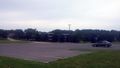
The Hash-mobile, parked in the school lot.
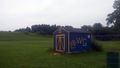
Walking across the field, I can only assume this nice shed houses the sporting equipment.
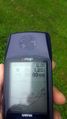
Made it.
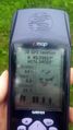
Accuracy.
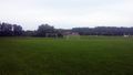
View from the hash, looking across the field back at the school.
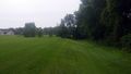
View down the edge of the field, looking South.

Glad I made a short detour for a quick adventure.


Ribbons
This user earned the Land geohash achievement
|
Pedalpusher earned the Consecutive geohash achievement
|