Difference between revisions of "2017-12-23 47 -122"
From Geohashing
imported>Thomcat ([live picture]Wishing tree) |
imported>Thomcat ([live] Next stop, lake view cem.) |
||
| Line 22: | Line 22: | ||
*Going to follow Interlake Boulevard from the North End down towards the geohash. Should be a nice drive. -- [[User:Thomcat|Thomcat]] ([[User talk:Thomcat|talk]]) 15:34, 23 December 2017 (PST) | *Going to follow Interlake Boulevard from the North End down towards the geohash. Should be a nice drive. -- [[User:Thomcat|Thomcat]] ([[User talk:Thomcat|talk]]) 15:34, 23 December 2017 (PST) | ||
| + | |||
| + | *Next stop, lake view cem. -- [[User:Thomcat|Thomcat]] ([[User talk:Thomcat|talk]]) [http://www.openstreetmap.org/?lat=47.63231890&lon=-122.30645260&zoom=16&layers=B000FTF @47.6323,-122.3065] 16:11, 23 December 2017 (PST) | ||
== Tracklog == | == Tracklog == | ||
<!-- if your GPS device keeps a log, you may post a link here --> | <!-- if your GPS device keeps a log, you may post a link here --> | ||
Revision as of 00:11, 24 December 2017
| Sat 23 Dec 2017 in Seattle: 47.6323860, -122.3064161 geohashing.info google osm bing/os kml crox |
Location
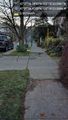
One block from Interlaken Park and two blocks from the Capitol Hill Wishing Tree on E. Galer.
Participants
Plans
Meet at 4:00, then make our way to Chucks for a pint.
Expedition
- Going to follow Interlake Boulevard from the North End down towards the geohash. Should be a nice drive. -- Thomcat (talk) 15:34, 23 December 2017 (PST)
- Next stop, lake view cem. -- Thomcat (talk) @47.6323,-122.3065 16:11, 23 December 2017 (PST)
Tracklog
Photos
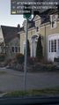
Entrance @47.6418,-122.3166
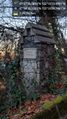
Boren memorial @47.6365,-122.3108
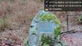
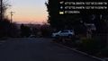
Here @47.6324,-122.3064
View west @47.6324,-122.3064
Foothills; wishing tree on the right @47.6322,-122.3053
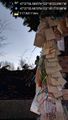
Wishing moon @47.6322,-122.3049
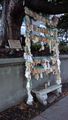
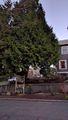
Wishing tree
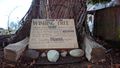
Detail
Wishing tree


Achievements