Difference between revisions of "2018-06-21 51 9"
imported>GeorgDerReisende (new report) |
imported>GeorgDerReisende (expedition report for Kaufungen-Niederkaufungen) |
||
| Line 1: | Line 1: | ||
| − | |||
| − | |||
| − | |||
| − | |||
| − | |||
| − | |||
| − | |||
| − | |||
| − | |||
| − | |||
{{meetup graticule | {{meetup graticule | ||
| lat=51 | | lat=51 | ||
| Line 19: | Line 9: | ||
== Location == | == Location == | ||
| − | + | ||
| + | The hash lay at the fence of an old and unused garden behind Windhäuser Straße in Kaufungen. | ||
== Participants == | == Participants == | ||
| − | + | ||
| − | + | [[User:GeorgDerReisende|GeorgDerReisende]] | |
== Plans == | == Plans == | ||
| − | + | ||
| + | Tram and walking. | ||
== Expedition == | == Expedition == | ||
| − | |||
| − | + | I took the tram to the station Niederkaufungen Mitte and walked through the village to the Windhäuser Straße. As I prepared the expedition I found two maps which showed an accessable way to the hash. But it began with a backyard-looking way, changed to a small footpath and ended in a defile. I fought through nettles and fallen trees and at least I arrived at the hash and only with a little dance I had success. An old ESRI satellite view shows green grass and trees, the Google map shows a new hut and a new swimming pool and the actual status is a desolated hut and a desolated swimming pool. | |
| − | |||
== Photos == | == Photos == | ||
| − | |||
| − | |||
| − | |||
<gallery perrow="5"> | <gallery perrow="5"> | ||
| + | Image:2018-06-21 51 9 GeorgDerReisende 3897.jpg | backyard way | ||
| + | Image:2018-06-21 51 9 GeorgDerReisende 3899.jpg | narrow foot path | ||
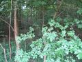
| + | Image:2018-06-21 51 9 GeorgDerReisende 3900.jpg | defile along the fence | ||
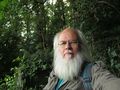
| + | Image:2018-06-21 51 9 GeorgDerReisende 3904.jpg | proof | ||
| + | Image:2018-06-21 51 9 GeorgDerReisende 3906.jpg | the forest behind the hash | ||
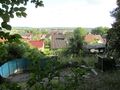
| + | Image:2018-06-21 51 9 GeorgDerReisende 3908.jpg | view over a garden to Niederkaufungen | ||
| + | Image:2018-06-21 51 9 GeorgDerReisende 3910.jpg | the geohasher | ||
</gallery> | </gallery> | ||
| Line 45: | Line 39: | ||
<!-- Add any achievement ribbons you earned below, or remove this section --> | <!-- Add any achievement ribbons you earned below, or remove this section --> | ||
| − | + | {{land geohash | latitude = 51 | longitude = 9 | date = 2018-06-21 | name = GeorgDerReisende }} | |
| − | |||
| − | |||
| − | + | [[Category:Expeditions]] | |
| − | + | [[Category:Expeditions with photos]] | |
| − | |||
| − | |||
| − | |||
| − | |||
| − | |||
| − | |||
| − | |||
| − | |||
| − | |||
| − | |||
| − | |||
| − | |||
| − | |||
| − | |||
[[Category:Coordinates reached]] | [[Category:Coordinates reached]] | ||
| − | |||
| − | |||
| − | |||
| − | |||
| − | |||
| − | |||
| − | |||
| − | |||
| − | |||
| − | |||
| − | |||
| − | |||
| − | |||
| − | |||
| − | |||
| − | |||
| − | |||
| − | |||
Revision as of 13:32, 25 June 2018
| Thu 21 Jun 2018 in 51,9: 51.2877145, 9.6003992 geohashing.info google osm bing/os kml crox |
Location
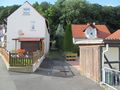
The hash lay at the fence of an old and unused garden behind Windhäuser Straße in Kaufungen.
Participants
Plans
Tram and walking.
Expedition
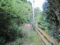
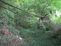
I took the tram to the station Niederkaufungen Mitte and walked through the village to the Windhäuser Straße. As I prepared the expedition I found two maps which showed an accessable way to the hash. But it began with a backyard-looking way, changed to a small footpath and ended in a defile. I fought through nettles and fallen trees and at least I arrived at the hash and only with a little dance I had success. An old ESRI satellite view shows green grass and trees, the Google map shows a new hut and a new swimming pool and the actual status is a desolated hut and a desolated swimming pool.
Photos
backyard way
narrow foot path
defile along the fence
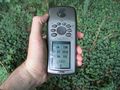
proof
the forest behind the hash
view over a garden to Niederkaufungen
the geohasher


Achievements
GeorgDerReisende earned the Land geohash achievement
|