Difference between revisions of "2018-07-08 49 8"
imported>DODO (→Photos) |
imported>DODO (→Achievements) |
||
| Line 56: | Line 56: | ||
{{#vardefine:ribbonwidth|800px}} | {{#vardefine:ribbonwidth|800px}} | ||
<!-- Add any achievement ribbons you earned below, or remove this section --> | <!-- Add any achievement ribbons you earned below, or remove this section --> | ||
| + | {{land geohash | ||
| + | | latitude = 49 | ||
| + | | longitude = 8 | ||
| + | | date = 2018-07-08 | ||
| + | | name = DODO | ||
| + | }} | ||
| − | |||
| − | |||
| − | |||
| − | |||
| − | |||
| − | |||
| − | |||
| − | |||
| − | |||
| − | |||
| − | |||
| − | |||
| − | |||
[[Category:Expeditions]] | [[Category:Expeditions]] | ||
| − | |||
[[Category:Expeditions with photos]] | [[Category:Expeditions with photos]] | ||
| − | |||
| − | |||
| − | |||
| − | |||
| − | |||
[[Category:Coordinates reached]] | [[Category:Coordinates reached]] | ||
| − | |||
| − | |||
| − | |||
| − | |||
| − | |||
| − | |||
| − | |||
| − | |||
| − | |||
| − | |||
| − | |||
| − | |||
| − | |||
| − | |||
| − | |||
| − | |||
| − | |||
| − | |||
Revision as of 14:40, 8 July 2018
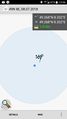
| Sun 8 Jul 2018 in 49,8: 49.2681909, 8.3321251 geohashing.info google osm bing/os kml crox |
Location
At the edge of Schwegenheim, less than 3 KM from 2018-07-05_49_8.
Participants
Plans
I had to go to Germersheim today for family reasons. So the lady and I decided to go there by bike. I wanted to leave early and visit the hash on my way home.
Expedition
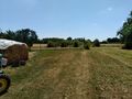
I left Germersheim around 12:30 and reached Schwabenheim around 1 o'clock. I had some difficulties to find the right way in Schwabenheim, because I wasn't fully equipped and couldn't see my phone while I was riding. But in the end I found the path that lead near the hash. There were houses with fenced gardens to my right all the way so I didn't expect the cashpoint to be reachable, but when I finally reached the lot, it emerged to be a slightly fenced lawn with a staple of wood and a tractor on it. There was a site fence or half of its width, but the other half was free, and I had only 30 meters to go. Worth to try any. I just walked on the lawn, took some pictures and left again, riding home to Speyer with another success.
Tracklog
8,8 KM by bike from Germersheim to the hash and another 9,8 km from the hash to Speyer.
Photos
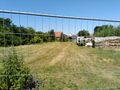
looks like a fenced place...
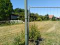
but the fence just ends
proof
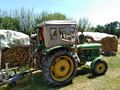
view to the east and the tractor
view to the south and my bike (proof of transport also)
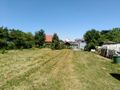
view to the north and (probably) the owners house)

view to the west and the happy hashers face in front


Achievements
DODO earned the Land geohash achievement
|