Difference between revisions of "2018-11-03 52 4"
From Geohashing
imported>Palmpje |
imported>Palmpje |
||
| Line 1: | Line 1: | ||
| − | |||
| − | |||
| − | |||
| − | |||
| − | |||
| − | |||
| − | |||
| − | |||
| − | |||
| − | |||
{{meetup graticule | {{meetup graticule | ||
| − | | lat= | + | | lat=52 |
| lon=4 | | lon=4 | ||
| date=2018-11-03 | | date=2018-11-03 | ||
}} | }} | ||
| − | |||
| − | |||
__NOTOC__ | __NOTOC__ | ||
== Location == | == Location == | ||
| − | + | * Van Lyndenweg (bicycle path next to it OR in the ditch next to that), Lisse - very close to the Keukenhof flower gardens. | |
== Participants == | == Participants == | ||
| − | + | * [[User: Palmpje | Palmpje]] | |
| − | |||
== Plans == | == Plans == | ||
| − | + | * Drive there (about 5km), park near the hashpoint, hope it's not in the ditch. | |
== Expedition == | == Expedition == | ||
| − | + | * Reached it at 11:50, sadly I could not manage to get there at hash-o-clock so this has to do. The expedition was fairly uneventful and the road was very quiet. In springtime it is BOOMING with tourists here as the flower fields are in fool bloom and the flowershow attracts about a zillion visitors. Of course, living almost next door I never go there. | |
| − | + | Left a chalk mark but on the footpath - the bicycle path was shared with the road but there is a separate footpath. Sadly the picture was not on my phone? | |
| − | |||
== Photos == | == Photos == | ||
<!-- Insert pictures between the gallery tags using the following format: | <!-- Insert pictures between the gallery tags using the following format: | ||
| − | + | ||
--> | --> | ||
<gallery perrow="5"> | <gallery perrow="5"> | ||
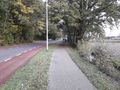
| + | Image:20181103 52 4 ZeroMeter.jpg | Right here | ||
| + | Image:20181103_52_4_West.jpg | West, in spring nice tulips here | ||
| + | Image:20181103_52_4_South.jpg | South, follow road for FC Lisse soccer | ||
| + | Image:20181103_52_4_East.jpg | East, across the road Keukenhof forest | ||
| + | Image:20181103_52_4_North.jpg | North, Palmpje's car behind lightpost | ||
| + | Image:20181103 52 4 VagueHasher.jpg | Hasher - anon, hashpoint is on the path to the left | ||
</gallery> | </gallery> | ||
== Achievements == | == Achievements == | ||
{{#vardefine:ribbonwidth|800px}} | {{#vardefine:ribbonwidth|800px}} | ||
| − | + | {{land geohash | latitude = 52 | longitude = 4 | date = 2018-11-03 | name = [[User: Palmpje]]}} | |
| − | |||
| − | |||
| − | |||
| − | [[ | ||
| − | |||
| − | |||
| − | |||
| − | |||
| − | |||
| − | |||
| − | |||
| − | |||
| − | |||
| − | |||
[[Category:Expeditions]] | [[Category:Expeditions]] | ||
| − | |||
[[Category:Expeditions with photos]] | [[Category:Expeditions with photos]] | ||
| − | |||
| − | |||
| − | |||
| − | |||
| − | |||
[[Category:Coordinates reached]] | [[Category:Coordinates reached]] | ||
| − | |||
| − | |||
| − | |||
| − | |||
| − | |||
| − | |||
| − | |||
| − | |||
| − | |||
| − | |||
| − | |||
| − | |||
| − | |||
| − | |||
| − | |||
| − | |||
| − | |||
| − | |||
Revision as of 13:35, 5 November 2018
| Sat 3 Nov 2018 in 52,4: 52.2645585, 4.5462871 geohashing.info google osm bing/os kml crox |
Location
- Van Lyndenweg (bicycle path next to it OR in the ditch next to that), Lisse - very close to the Keukenhof flower gardens.
Participants
Plans
- Drive there (about 5km), park near the hashpoint, hope it's not in the ditch.
Expedition
- Reached it at 11:50, sadly I could not manage to get there at hash-o-clock so this has to do. The expedition was fairly uneventful and the road was very quiet. In springtime it is BOOMING with tourists here as the flower fields are in fool bloom and the flowershow attracts about a zillion visitors. Of course, living almost next door I never go there.
Left a chalk mark but on the footpath - the bicycle path was shared with the road but there is a separate footpath. Sadly the picture was not on my phone?
Photos
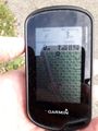
Right here
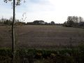
West, in spring nice tulips here
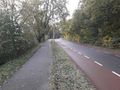
South, follow road for FC Lisse soccer
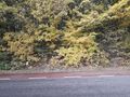
East, across the road Keukenhof forest
North, Palmpje's car behind lightpost
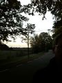
Hasher - anon, hashpoint is on the path to the left


Achievements
User: Palmpje earned the Land geohash achievement
|