Difference between revisions of "2019-02-19 51 9"
From Geohashing
imported>GeorgDerReisende (new report) |
imported>GeorgDerReisende (expedition report for Sontra-Berneburg) |
||
| Line 1: | Line 1: | ||
| − | |||
| − | |||
| − | |||
| − | |||
| − | |||
| − | |||
| − | |||
| − | |||
| − | |||
| − | |||
{{meetup graticule | {{meetup graticule | ||
| lat=51 | | lat=51 | ||
| Line 19: | Line 9: | ||
== Location == | == Location == | ||
| − | + | ||
| + | The hash lay on a meadow south of Berneburg. | ||
== Participants == | == Participants == | ||
| − | + | ||
| − | + | [[User:GeorgDerReisende|GeorgDerReisende]] | |
== Plans == | == Plans == | ||
| − | + | ||
| + | Tram and train and bus and walking. | ||
== Expedition == | == Expedition == | ||
| − | |||
| − | + | I started at home at 12:20 and arrived at Berneburg at 15:30. 15 minutes later I arrived at the hash. Because [[User:Digiphono|Digiphono]] announced himself for 3 pm to 3:30 pm, I waited there until 15:30, but no Digiphono. Then I traveled home. | |
| − | |||
== Photos == | == Photos == | ||
| − | |||
| − | |||
| − | |||
<gallery perrow="5"> | <gallery perrow="5"> | ||
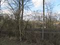
| + | 2019-02-19 51 9 GeorgDerReisende 8567.jpg | arrived by bus, the hash area in the background | ||
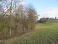
| + | 2019-02-19 51 9 GeorgDerReisende 8582.jpg | the field way between the railway on the left and the hash on the right | ||
| + | 2019-02-19 51 9 GeorgDerReisende 8583.jpg | the hash | ||
| + | 2019-02-19 51 9 GeorgDerReisende 8584.jpg | proof | ||
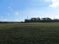
| + | 2019-02-19 51 9 GeorgDerReisende 8587.jpg | looking east | ||
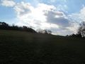
| + | 2019-02-19 51 9 GeorgDerReisende 8588.jpg | south | ||
| + | 2019-02-19 51 9 GeorgDerReisende 8590.jpg | west | ||
| + | 2019-02-19 51 9 GeorgDerReisende 8591.jpg | north | ||
| + | 2019-02-19 51 9 GeorgDerReisende 8592.jpg | the geohasher | ||
</gallery> | </gallery> | ||
| − | + | [[Category:Expeditions]] | |
| − | |||
| − | |||
| − | + | [[Category:Expeditions with photos]] | |
| − | |||
| − | [[Category: | ||
| − | |||
| − | |||
| − | |||
| − | |||
| − | |||
| − | |||
| − | |||
| − | |||
| − | |||
| − | |||
| − | |||
| − | |||
| − | |||
| − | |||
| − | |||
| − | |||
| − | |||
| − | |||
| − | |||
| − | |||
[[Category:Coordinates reached]] | [[Category:Coordinates reached]] | ||
| − | |||
| − | |||
| − | |||
| − | |||
| − | |||
| − | |||
| − | |||
| − | |||
| − | |||
| − | |||
| − | |||
| − | |||
| − | |||
| − | |||
| − | |||
| − | |||
| − | |||
| − | |||
Revision as of 19:45, 19 February 2019
| Tue 19 Feb 2019 in 51,9: 51.0550410, 9.8858558 geohashing.info google osm bing/os kml crox |
Location
The hash lay on a meadow south of Berneburg.
Participants
Plans
Tram and train and bus and walking.
Expedition
I started at home at 12:20 and arrived at Berneburg at 15:30. 15 minutes later I arrived at the hash. Because Digiphono announced himself for 3 pm to 3:30 pm, I waited there until 15:30, but no Digiphono. Then I traveled home.
Photos
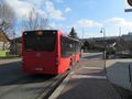
arrived by bus, the hash area in the background
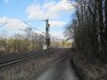
the field way between the railway on the left and the hash on the right
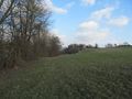
the hash
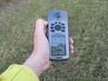
proof
looking east
south
west
north
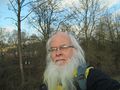
the geohasher


