Difference between revisions of "2008-06-12 -34 138"
From Geohashing
imported>FippeBot m (Location) |
|||
| Line 7: | Line 7: | ||
== About == | == About == | ||
| − | Thursday's geohash for | + | Thursday's geohash for [[Adelaide North, Australia|northern Adelaide]] was about 8.313 miles (43897 feet)(~13 km) offshore so a point on the nearby coast was chosen, located at -34.79569105, 138.48176479. |
The location turned out to be right on the end of a breakwater near the suburb of Osborne, a shown in the photos below. | The location turned out to be right on the end of a breakwater near the suburb of Osborne, a shown in the photos below. | ||
Latest revision as of 11:24, 28 January 2021
| Thu 12 Jun 2008 in -34,138: -34.7906706, 138.3355328 geohashing.info google osm bing/os kml crox |
About
Thursday's geohash for northern Adelaide was about 8.313 miles (43897 feet)(~13 km) offshore so a point on the nearby coast was chosen, located at -34.79569105, 138.48176479.
The location turned out to be right on the end of a breakwater near the suburb of Osborne, a shown in the photos below.
People
One group (around 5 pm) turned up
- Nathan and BobTheFish
Photos
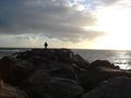
Looking out at the breakwater
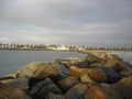
Looking back at the suburbs from near the end of the breakwater
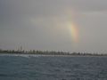
Rainbow viewed from out on the breakwater
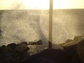
View at the end of the breakwater. The original geohash would be 8 miles out to sea in that direction


