Difference between revisions of "2008-06-15 49 11"
imported>Thomcat (Success/failure category added) |
imported>Dawidi (+more pics for an old expedition) |
||
| Line 18: | Line 18: | ||
<gallery> | <gallery> | ||
| + | Image:2008-06-15 49 11 cave.jpg|A small cave next to the cycleway, where I rested on a bench in the sun for a bit. | ||
| + | Image:2008-06-15 49 11 pruefeningweg.jpg|A few km before the hash. | ||
Image:2008-06-15 49 11 siebeneichen-dawidi-1.jpg|Bench marked ;-) | Image:2008-06-15 49 11 siebeneichen-dawidi-1.jpg|Bench marked ;-) | ||
Image:2008-06-15 49 11 siebeneichen-dawidi-2.jpg|The hashpoint is in the middle of that field. | Image:2008-06-15 49 11 siebeneichen-dawidi-2.jpg|The hashpoint is in the middle of that field. | ||
Revision as of 10:16, 28 February 2009
| Sun 15 Jun 2008 in Nuremberg, Germany: 49.4753808, 11.7612767 geohashing.info google osm bing/os kml crox |
dawidi
My first attempt at a geohash. I live in Regensburg, so it was a ~80km bicycle ride to get there and ~15km back to Amberg, from where I went home by train. But I wanted to collect GPS tracks of the cycle route for Openstreetmap anyway and the hash was just a bonus :)
I got to the hashpoint near the village Siebeneichen ("seven oaktrees", didn't count them) at around 15:30, it had just begun to rain a little on an otherwise cool, but sunny day. Couldn't reach the exact spot as it was in a field, but 80m to the south there was a nice big tree (i.e. rain shelter) with a bench to sit on.
Rested, nommed some candy, took pictures, and arranged twigs on the bench to say "xkcd" to the next visitor. Left at 16:00, just in time to miss the train (so I had to wait in Amberg for nearly an hour).
No one else went there, apparently, but I didn't expect otherwise.
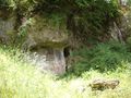
A small cave next to the cycleway, where I rested on a bench in the sun for a bit.
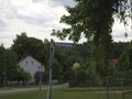
A few km before the hash.
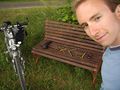
Bench marked ;-)
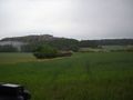
The hashpoint is in the middle of that field.


