Difference between revisions of "2008-06-24 53 9"
From Geohashing
imported>Hermann |
imported>Hermann m |
||
| Line 24: | Line 24: | ||
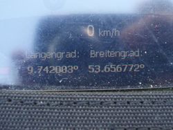
Image:Hermann_Geohash_2008-06-24_Hamburg_Navi.jpg | GPS at the photo-location | Image:Hermann_Geohash_2008-06-24_Hamburg_Navi.jpg | GPS at the photo-location | ||
</gallery> | </gallery> | ||
| + | |||
| + | [[Category:Expeditions]] | ||
| + | [[Category:Expeditions with photos]] | ||
| + | [[Category:Coordinates not reached]] | ||
Revision as of 21:29, 6 August 2008
| Tue 24 Jun 2008 in 53,9: 53.6568556, 9.7411095 geohashing.info google osm bing/os kml crox |
About
The coordinates of this geohash are
53.656855630923445, 9.741109459715217
The hash was south "Appen" in a sawmp.
Expedition
Hermann and Felix were there:
It was a sunny day and medium temperatures. All in all ideal weather for a small bikeride. We reached the fields south from "Appen" without any troubles. As we got closer, the land turned out not to be fallow ground but a swamp covered with reed and nettels. We circumwent the area but didn't find a way to the hash. Therefore, we estimated the nearest point and took our photos there:
Technical details:
- Distance: 24km (12km respectively)
- Photos
GPS at the photo-location

